
Geographic Region: USA-ARKANSAS
Feature: LITTLE ROCK,ARKANSAS RIVER,OXBOW LAKES,AGRICULTURE
|
Geographic Region: USA-ARKANSAS Feature: LITTLE ROCK,ARKANSAS RIVER,OXBOW LAKES,AGRICULTURE |
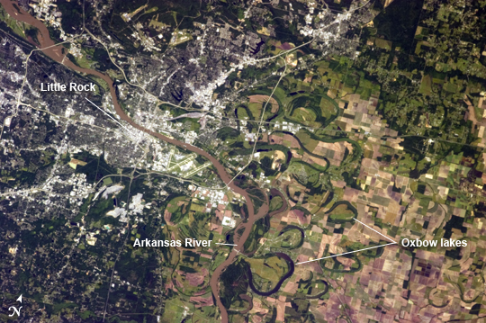 |
| Little Rock Metropolitan Area, Arkansas The capitol city of the State of Arkansas, Little Rock, occupies a position near the geographic center of the state between the eroded remnants of the Ouachita Mountains to the west, the Mississippi River Alluvial Plain to the east, and the West Gulf Coastal Plain to the south. This astronaut photograph taken from the International Space Station highlights the Little Rock metropolitan area and surrounding region. Urban and suburban areas appear light to dark gray in the image, while large facilities and buildings (commercial/industrial, public arenas, etc.) stand out due to expansive light-colored roofs. The Arkansas River separates Little Rock on the south bank from North Little Rock on the north bank. Frequent changes in the river channel's position through geologic time are recorded as numerous current (and former) oxbow lakes visible to the east of the current river channel (image right) within extensive agricultural fields. Oxbow lakes are formed on river floodplains when wide meander bends in a river are "pinched off" due to the river cutting a shorter channel across the bend. This forms a lake, which typically becomes filled in with sediment over time, with vegetation forming a distinctive curved pattern visible from above. The city of Little Rock takes its name from a small rock outcrop located on the south bank of the Arkansas River. This outcrop served as a landmark for navigating the river during the city's early development as a center of regional commerce - a role the city still enjoys today. |
| Images: | All Available Images Low-Resolution 302k |
|
| Mission: | ISS036 |
|
| Roll - Frame: | E - 3918 |
|
| Geographical Name: | USA-ARKANSAS |
|
| Features: | LITTLE ROCK,ARKANSAS RIVER,OXBOW LAKES,AGRICULTURE |
|
| Center Lat x Lon: | 34.7N x 92.2W |
|
| Film Exposure: | N=Normal exposure, U=Under exposed, O=Over exposed, F=out of Focus |
|
| Percentage of Cloud Cover-CLDP: | 10 |
|
| Camera:: | N5 |
|
| Camera Tilt: | 22 | LO=Low Oblique, HO=High Oblique, NV=Near Vertical |
| Camera Focal Length: | 400 |
|
| Nadir to Photo Center Direction: | SW | The direction from the nadir to the center point, N=North, S=South, E=East, W=West |
| Stereo?: | Y=Yes there is an adjacent picture of the same area, N=No there isn't |
|
| Orbit Number: | |
|
| Date: | 20130524 | YYYYMMDD |
| Time: | 143817 | GMT HHMMSS |
| Nadir Lat: | 35.7N |
Latitude of suborbital point of spacecraft |
| Nadir Lon: | 91.1W |
Longitude of suborbital point of spacecraft |
| Sun Azimuth: | 94 | Clockwise angle in degrees from north to the sun measured at the nadir point |
| Space Craft Altitude: | 225 | nautical miles |
| Sun Elevation: | 44 | Angle in degrees between the horizon and the sun, measured at the nadir point |
| Land Views: | |
|
| Water Views: | CHANNEL, LAKE, RIVER |
|
| Atmosphere Views: | |
|
| Man Made Views: | |
|
| City Views: | LITTLE ROCK |
|
Photo is not associated with any sequences | ||
| NASA Home Page |
JSC Home Page |
JSC Digital Image Collection |
Earth Science & Remote Sensing |
|
This service is provided by the International Space Station program and the JSC Earth Science & Remote Sensing Unit, ARES Division, Exploration Integration Science Directorate.

|