
Geographic Region: AUSTRALIA-Q
Feature: HERVEY BAY,URANGAN,GREAT SANDY STRAIT,FRASER ISLAND,PACIFIC OCEAN
|
Geographic Region: AUSTRALIA-Q Feature: HERVEY BAY,URANGAN,GREAT SANDY STRAIT,FRASER ISLAND,PACIFIC OCEAN |
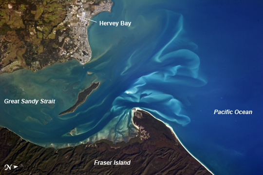 |
| Hervey Bay, Queensland, Australia The northern end of the Great Sandy Strait and Hervey Bay are highlighted in this astronaut photograph from the International Space Station. The Strait is an estuary that separates the mainland coastline of the state of Queensland, Australia from neighboring Fraser Island. The mainland side of the Strait includes the city of Hervey Bay, visible at image top center. Other communities that have become part of the larger metropolitan area include Scarness, Booral, and Urangan. A small vegetated island and shallow sand bars of the Great Sandy Strait are visible at image center left, while submerged sands appear as bright blue flowing ribbons at image center. A small, bright white exposure of sand is visible above the water level near the center point of the image. While once a major freighting center for the sugar cane industry, the local economy is now largely based on tourism, with whale watching tours a popular attraction. The Great Sandy Strait estuary provides habitat for breeding fish, crustaceans, turtles, and other sea life, as well as a wide variety of birds including non-breeding wading species including Eastern Curlews, Bat-tailed Godwits, and Pied Oystercatchers. Nearby Fraser Island is the world's largest sand island and a World Heritage site. |
| Images: | All Available Images Low-Resolution 168k |
|
| Mission: | ISS036 |
|
| Roll - Frame: | E - 28444 |
|
| Geographical Name: | AUSTRALIA-Q |
|
| Features: | HERVEY BAY,URANGAN,GREAT SANDY STRAIT,FRASER ISLAND,PACIFIC OCEAN |
|
| Center Lat x Lon: | 25.2S x 153.0E |
|
| Film Exposure: | N=Normal exposure, U=Under exposed, O=Over exposed, F=out of Focus |
|
| Percentage of Cloud Cover-CLDP: | 10 |
|
| Camera:: | N5 |
|
| Camera Tilt: | 15 | LO=Low Oblique, HO=High Oblique, NV=Near Vertical |
| Camera Focal Length: | 400 |
|
| Nadir to Photo Center Direction: | NE | The direction from the nadir to the center point, N=North, S=South, E=East, W=West |
| Stereo?: | Y=Yes there is an adjacent picture of the same area, N=No there isn't |
|
| Orbit Number: | |
|
| Date: | 20130803 | YYYYMMDD |
| Time: | 215743 | GMT HHMMSS |
| Nadir Lat: | 25.9S |
Latitude of suborbital point of spacecraft |
| Nadir Lon: | 152.3E |
Longitude of suborbital point of spacecraft |
| Sun Azimuth: | 60 | Clockwise angle in degrees from north to the sun measured at the nadir point |
| Space Craft Altitude: | 226 | nautical miles |
| Sun Elevation: | 18 | Angle in degrees between the horizon and the sun, measured at the nadir point |
| Land Views: | ISLAND |
|
| Water Views: | BAY, ESTUARY, STRAIT |
|
| Atmosphere Views: | |
|
| Man Made Views: | |
|
| City Views: | |
|
Photo is not associated with any sequences | ||
| NASA Home Page |
JSC Home Page |
JSC Digital Image Collection |
Earth Science & Remote Sensing |
|
This service is provided by the International Space Station program and the JSC Earth Science & Remote Sensing Unit, ARES Division, Exploration Integration Science Directorate.

|