
Geographic Region: CANADA-O
Feature: LAKE SUPERIOR,WAVE PATTERNS,ISLE ROYAL,SLATE ISLANDS,SUNGLINT
|
Geographic Region: CANADA-O Feature: LAKE SUPERIOR,WAVE PATTERNS,ISLE ROYAL,SLATE ISLANDS,SUNGLINT |
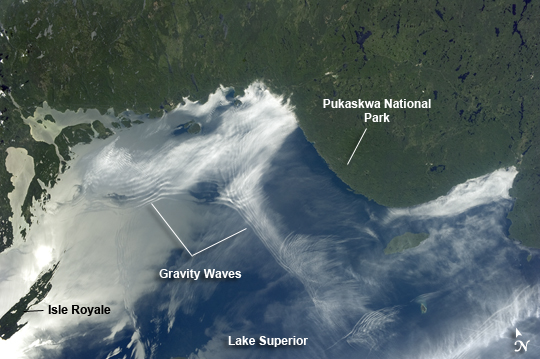 |
| Gravity Waves and Sunglint, Lake Superior Note: This caption refers to the image versions labeled "NASA's Earth Observatory web site". From the vantage point of the International Space Station, astronauts frequently observe Earth atmospheric and surface phenomena in ways impossible to view from the ground. Two such phenomena--gravity waves and sunglint--are illustrated in this astronaut photograph of northeastern Lake Superior. The Canadian Shield of southern Ontario (image top) is covered with extensive green forest canopy typical of early summer. Offshore, and to the west and southwest of Pukaskwa National Park several distinct sets of parallel cloud bands are visible. Gravity waves are produced when moisture-laden air encounters imbalances in air density, such as might be expected when cool air flows over warmer air; this can cause the flowing air to oscillate up and down as it moves, causing clouds to condense as the air rises (cools) and evaporate away as the air sinks (warms). This produces parallel bands of clouds oriented perpendicular to the wind direction. The orientation of the cloud bands visible in this image, parallel to the coastlines, suggests that air flowing off of the land surfaces to the north is interacting with moist, stable air over the lake surface, creating gravity waves. The second phenomenon--sunglint--effects the water surface around and to the northeast of Isle Royale (image left). Sunglint is caused by light reflection off a water surface; some of the reflected light travels directly back towards the observer, resulting in a bright mirror-like appearance over large expanses of water. Water currents and changes in surface tension (typically caused by presence of oils or surfactants) alter the reflective properties of the water, and can be highlighted by sunglint. For example, surface water currents are visible to the east of Isle Royale that are oriented similarly to the gravity waves - suggesting that they too are the product of winds moving off of the land surface. |
| Images: | All Available Images Low-Resolution 181k |
|
| Mission: | ISS036 |
|
| Roll - Frame: | E - 11843 |
|
| Geographical Name: | CANADA-O |
|
| Features: | LAKE SUPERIOR,WAVE PATTERNS,ISLE ROYAL,SLATE ISLANDS,SUNGLINT |
|
| Center Lat x Lon: | 48.5N x 86.5W |
|
| Film Exposure: | N=Normal exposure, U=Under exposed, O=Over exposed, F=out of Focus |
|
| Percentage of Cloud Cover-CLDP: | 10 |
|
| Camera:: | N5 |
|
| Camera Tilt: | 28 | LO=Low Oblique, HO=High Oblique, NV=Near Vertical |
| Camera Focal Length: | 50 |
|
| Nadir to Photo Center Direction: | SW | The direction from the nadir to the center point, N=North, S=South, E=East, W=West |
| Stereo?: | Y=Yes there is an adjacent picture of the same area, N=No there isn't |
|
| Orbit Number: | |
|
| Date: | 20130624 | YYYYMMDD |
| Time: | 203352 | GMT HHMMSS |
| Nadir Lat: | 49.4N |
Latitude of suborbital point of spacecraft |
| Nadir Lon: | 84.8W |
Longitude of suborbital point of spacecraft |
| Sun Azimuth: | 248 | Clockwise angle in degrees from north to the sun measured at the nadir point |
| Space Craft Altitude: | 218 | nautical miles |
| Sun Elevation: | 48 | Angle in degrees between the horizon and the sun, measured at the nadir point |
| Land Views: | FOREST |
|
| Water Views: | LAKE, SUNGLINT |
|
| Atmosphere Views: | |
|
| Man Made Views: | |
|
| City Views: | ONTARIO, SUPERIOR |
|
Photo is not associated with any sequences | ||
| NASA Home Page |
JSC Home Page |
JSC Digital Image Collection |
Earth Science & Remote Sensing |
|
This service is provided by the International Space Station program and the JSC Earth Science & Remote Sensing Unit, ARES Division, Exploration Integration Science Directorate.

|