
Geographic Region: MEXICO
Feature: YUMA,SAN DIEGO,MEXICALI,SALTON SEA,COLORADO RIVER DELTA,TIJUANA
|
Geographic Region: MEXICO Feature: YUMA,SAN DIEGO,MEXICALI,SALTON SEA,COLORADO RIVER DELTA,TIJUANA |
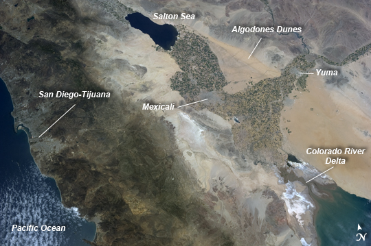 |
| Salton Trough, USA and Mexico Note: This caption refers to the image versions labeled "NASA's Earth Observatory web site". The Imperial and Coachella Valleys of southern California - and the corresponding Mexicali Valley and Colorado River Delta in Mexico - are part of the Salton Trough, a large geologic structure known to geologists as a graben or rift valley that extends into the Gulf of California. The trough is a geologically complex zone formed by interaction of the San Andreas transform fault system that is, broadly speaking, moving southern California towards Alaska; and the northward motion of the Gulf of California segment of the East Pacific Rise that continues to widen the Gulf of California by sea-floor spreading. Sediments deposited by the Colorado River have been filling the northern rift valley (the Salton Trough) for the past several million years, excluding the waters of the Gulf of California and providing a fertile environment - together with irrigation--for the development of extensive agriculture in the region (visible as green and yellow-brown fields at image center). The Salton Sea, a favorite landmark of astronauts in low earth orbit, was formed by an irrigation canal rupture in 1905, and today is sustained by agricultural runoff water. A wide array of varying landforms and land uses in the Salton Trough are visible from space. In addition to the agricultural fields and Salton Sea, easily visible metropolitan areas include Yuma, AZ (image top left); Mexicali, Baja California, Mexico(image center); and the San Diego-Tijuana conurbation on the Pacific Coast (image left). The approximately 72 kilometer long Algodones Dunefield is visible at image top right. |
| Images: | All Available Images Low-Resolution 199k |
|
| Mission: | ISS036 |
|
| Roll - Frame: | E - 11034 |
|
| Geographical Name: | MEXICO |
|
| Features: | YUMA,SAN DIEGO,MEXICALI,SALTON SEA,COLORADO RIVER DELTA,TIJUANA |
|
| Center Lat x Lon: | 32.5N x 115.5W |
|
| Film Exposure: | N=Normal exposure, U=Under exposed, O=Over exposed, F=out of Focus |
|
| Percentage of Cloud Cover-CLDP: | 10 |
|
| Camera:: | N5 |
|
| Camera Tilt: | 17 | LO=Low Oblique, HO=High Oblique, NV=Near Vertical |
| Camera Focal Length: | 50 |
|
| Nadir to Photo Center Direction: | N | The direction from the nadir to the center point, N=North, S=South, E=East, W=West |
| Stereo?: | Y=Yes there is an adjacent picture of the same area, N=No there isn't |
|
| Orbit Number: | |
|
| Date: | 20130621 | YYYYMMDD |
| Time: | 211531 | GMT HHMMSS |
| Nadir Lat: | 31.4N |
Latitude of suborbital point of spacecraft |
| Nadir Lon: | 115.4W |
Longitude of suborbital point of spacecraft |
| Sun Azimuth: | 255 | Clockwise angle in degrees from north to the sun measured at the nadir point |
| Space Craft Altitude: | 220 | nautical miles |
| Sun Elevation: | 68 | Angle in degrees between the horizon and the sun, measured at the nadir point |
| Land Views: | COAST, RIFT, VALLEY |
|
| Water Views: | DELTA, GULF, RIVER, SEA |
|
| Atmosphere Views: | |
|
| Man Made Views: | AGRICULTURE |
|
| City Views: | MEXICALI, SAN DIEGO, YUMA |
|
Photo is not associated with any sequences | ||
| NASA Home Page |
JSC Home Page |
JSC Digital Image Collection |
Earth Science & Remote Sensing |
|
This service is provided by the International Space Station program and the JSC Earth Science & Remote Sensing Unit, ARES Division, Exploration Integration Science Directorate.

|