
Geographic Region: SAUDI ARABIA
Feature: TIRAN ISLAND,NABQ,STRAITS OF TIRAN,RED SEA,GULF OF AQABA
|
Geographic Region: SAUDI ARABIA Feature: TIRAN ISLAND,NABQ,STRAITS OF TIRAN,RED SEA,GULF OF AQABA |
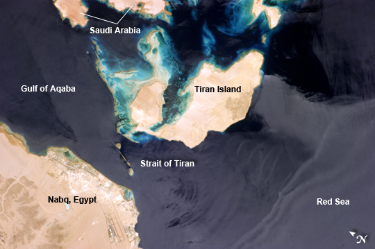 |
| Strait of Tiran, Red Sea and Gulf of Aqaba Note: This caption refers to the image versions labeled "NASA's Earth Observatory web site". The approximately 6 kilometer wide Strait of Tiran (also known as the Straits of Tiran) between the Egyptian mainland and Tiran Island separates the Gulf of Aqaba from the Red Sea, and provides two channels (290 m and 73 m deep, respectively) navigable by large ships bound for ports in Jordan and Israel. A smaller passage also exists between the east side of Tiran Island and Saudi Arabia, but this a single channel that is 16 meters deep. Due to its strategic position, control of the Strait has been an important factor in historical conflicts of the region, such as the Suez Crisis in 1956 and the Six-Day War in 1967. This astronaut photograph from the International Space Station (ISS) illustrates the morphology of the Strait. The relatively clear, deep water passages of the western Strait of Tiran are visible at image left, while the more sinuous shallow-water passage on the Saudi Arabia side can be seen at image top center. Light blue to turquoise areas around Tiran Island indicate shallow water, while the island itself is arid and largely free of vegetation. Coral reefs are also found in the Straits of Tiran and are a popular diving destination. The silvery sheen on the water surface within the Strait and the south of Tiran Island is sunglint - light reflecting off the water surface back towards the astronaut observer on the ISS . Disturbance to the water surface, as well as presence of substances such as oils and surfactants, can change the reflective properties of the water surface and highlight both surface waves and subsurface currents. For example, a large wave set is highlighted by sunglint at image lower right. |
| Images: | All Available Images Low-Resolution 168k |
|
| Mission: | ISS036 |
|
| Roll - Frame: | E - 10628 |
|
| Geographical Name: | SAUDI ARABIA |
|
| Features: | TIRAN ISLAND,NABQ,STRAITS OF TIRAN,RED SEA,GULF OF AQABA |
|
| Center Lat x Lon: | 28.0N x 34.5E |
|
| Film Exposure: | N=Normal exposure, U=Under exposed, O=Over exposed, F=out of Focus |
|
| Percentage of Cloud Cover-CLDP: | 10 |
|
| Camera:: | N5 |
|
| Camera Tilt: | 14 | LO=Low Oblique, HO=High Oblique, NV=Near Vertical |
| Camera Focal Length: | 400 |
|
| Nadir to Photo Center Direction: | SW | The direction from the nadir to the center point, N=North, S=South, E=East, W=West |
| Stereo?: | Y=Yes there is an adjacent picture of the same area, N=No there isn't |
|
| Orbit Number: | |
|
| Date: | 20130623 | YYYYMMDD |
| Time: | 102213 | GMT HHMMSS |
| Nadir Lat: | 28.5N |
Latitude of suborbital point of spacecraft |
| Nadir Lon: | 35.3E |
Longitude of suborbital point of spacecraft |
| Sun Azimuth: | 245 | Clockwise angle in degrees from north to the sun measured at the nadir point |
| Space Craft Altitude: | 220 | nautical miles |
| Sun Elevation: | 80 | Angle in degrees between the horizon and the sun, measured at the nadir point |
| Land Views: | ISLAND |
|
| Water Views: | CHANNEL, GULF, SEA, STRAIT, SUNGLINT, WAVE |
|
| Atmosphere Views: | |
|
| Man Made Views: | |
|
| City Views: | AQABA |
|
Photo is not associated with any sequences | ||
| NASA Home Page |
JSC Home Page |
JSC Digital Image Collection |
Earth Science & Remote Sensing |
|
This service is provided by the International Space Station program and the JSC Earth Science & Remote Sensing Unit, ARES Division, Exploration Integration Science Directorate.

|