
Geographic Region: RUSSIAN FEDERATION
Feature: BLACK SEA,PLANKTON BLOOM,NOVOROSSIYSK,ANAPA
|
Geographic Region: RUSSIAN FEDERATION Feature: BLACK SEA,PLANKTON BLOOM,NOVOROSSIYSK,ANAPA |
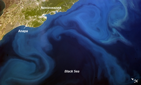 |
| Plankton Bloom, eastern Black Sea The Black Sea, a large inland water body that connects eastern Europe and Asia Minor, frequently hosts widespread blooms of phytoplankton during the local spring and summer seasons. This astronaut photograph, taken from the International Space Station, highlights a recent plankton bloom in the Black Sea's eastern half. The phytoplankton are visible as blue to turquoise streams and swirls, carried by currents along the coastline and further out towards the middle of the water body. The urban areas of Anapa and Novorossiysk (the largest Russian seaport on the Black Sea) are visible along the northern shoreline as grey-white regions nestled between the sea and uplands hosting limestone quarries. Phytoplankton occupies the base of most aquatic food chains, and therefore serves as the primary producers in these ecosystems, despite being microscopic in size. The term "phytoplankton" includes a number of organisms - cyanobacteria, diatoms, dinoflagellates, algae, and coccolithophores - that feed larger creatures such as fish and shrimp. The Black Sea receives contributions of freshwater from several river systems including the Danube, Dnieper, Dniester, and Don, but it is also connected to the saline Mediterranean and Marmara Seas. These same river systems can transport urban and agricultural runoff containing nutrients to the Black Sea; these nutrients can be consumed by phytoplankton and lead to blooms. |
| Images: | All Available Images Low-Resolution 134k |
|
| Mission: | ISS035 |
|
| Roll - Frame: | E - 40035 |
|
| Geographical Name: | RUSSIAN FEDERATION |
|
| Features: | BLACK SEA,PLANKTON BLOOM,NOVOROSSIYSK,ANAPA |
|
| Center Lat x Lon: | 43.5N x 37.0E |
|
| Film Exposure: | N=Normal exposure, U=Under exposed, O=Over exposed, F=out of Focus |
|
| Percentage of Cloud Cover-CLDP: | 10 |
|
| Camera:: | N5 |
|
| Camera Tilt: | 35 | LO=Low Oblique, HO=High Oblique, NV=Near Vertical |
| Camera Focal Length: | 50 |
|
| Nadir to Photo Center Direction: | SE | The direction from the nadir to the center point, N=North, S=South, E=East, W=West |
| Stereo?: | Y=Yes there is an adjacent picture of the same area, N=No there isn't |
|
| Orbit Number: | |
|
| Date: | 20130509 | YYYYMMDD |
| Time: | 110642 | GMT HHMMSS |
| Nadir Lat: | 44.8N |
Latitude of suborbital point of spacecraft |
| Nadir Lon: | 34.8E |
Longitude of suborbital point of spacecraft |
| Sun Azimuth: | 222 | Clockwise angle in degrees from north to the sun measured at the nadir point |
| Space Craft Altitude: | 222 | nautical miles |
| Sun Elevation: | 57 | Angle in degrees between the horizon and the sun, measured at the nadir point |
| Land Views: | |
|
| Water Views: | PLANKTON BLOOM, SEA |
|
| Atmosphere Views: | |
|
| Man Made Views: | |
|
| City Views: | ANAPA, NOVOROSSIYSK |
|
Photo is not associated with any sequences | ||
| NASA Home Page |
JSC Home Page |
JSC Digital Image Collection |
Earth Science & Remote Sensing |
|
This service is provided by the International Space Station program and the JSC Earth Science & Remote Sensing Unit, ARES Division, Exploration Integration Science Directorate.

|