
Geographic Region: PAKISTAN
Feature: KORANGI,INDUSTRIAL AREAS,INDUS RIVER DELTA, MANGROVES
|
Geographic Region: PAKISTAN Feature: KORANGI,INDUSTRIAL AREAS,INDUS RIVER DELTA, MANGROVES |
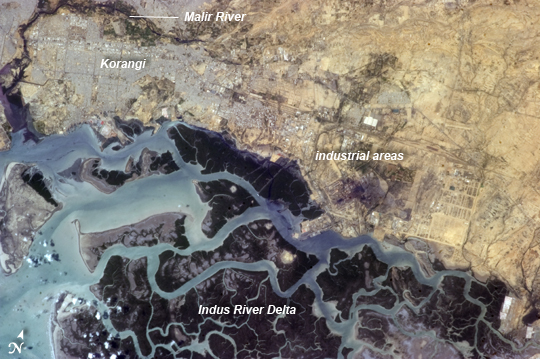 |
| Korangi, Pakistan Note: This caption refers to the image versions labeled "NASA's Earth Observatory web site". Korangi (or Korangi Town) is part of the Karachi metropolitan area of coastal Pakistan. This astronaut photograph from the International Space Station highlights the contrast between the highly urbanized and industrialized Korangi area (image top and image right) to dense green mangrove forests and waterways of the Indus River Delta to the south (image bottom and image left). Away from the river delta, vegetation cover reduces rapidly to the northeast (image top right). To the north and west, Korangi Town is bordered by the Malir River, one of two rivers (the other being the Lyari River, not shown) that pass through the Karachi metropolitan area. The river course of the Malir is marked by green riparian vegetation, which stands out vividly from orbit against the surrounding gray to tan urban areas. One of the largest industrial areas in Pakistan is located in Korangi (known as the Korangi Industrial Area, or KIA) - this region is visible at image center, and is marked by large buildings and lots, many having large white-roofed structures. A conspicuously dark region to the right of image center marks the location of steel works; while bare soil and built materials are present, significant vegetation cover also contributes to the dark tone. In addition to steel, the KIA also includes textile, pharmaceutical, automobile, chemical, and flour industry facilities. |
| Images: | All Available Images Low-Resolution 240k |
|
| Mission: | ISS035 |
|
| Roll - Frame: | E - 24919 |
|
| Geographical Name: | PAKISTAN |
|
| Features: | KORANGI,INDUSTRIAL AREAS,INDUS RIVER DELTA, MANGROVES |
|
| Center Lat x Lon: | 24.8N x 67.3E |
|
| Film Exposure: | N=Normal exposure, U=Under exposed, O=Over exposed, F=out of Focus |
|
| Percentage of Cloud Cover-CLDP: | 10 |
|
| Camera:: | N5 |
|
| Camera Tilt: | 14 | LO=Low Oblique, HO=High Oblique, NV=Near Vertical |
| Camera Focal Length: | 400 |
|
| Nadir to Photo Center Direction: | W | The direction from the nadir to the center point, N=North, S=South, E=East, W=West |
| Stereo?: | Y=Yes there is an adjacent picture of the same area, N=No there isn't |
|
| Orbit Number: | |
|
| Date: | 20130420 | YYYYMMDD |
| Time: | 091927 | GMT HHMMSS |
| Nadir Lat: | 25.1N |
Latitude of suborbital point of spacecraft |
| Nadir Lon: | 68.2E |
Longitude of suborbital point of spacecraft |
| Sun Azimuth: | 249 | Clockwise angle in degrees from north to the sun measured at the nadir point |
| Space Craft Altitude: | 222 | nautical miles |
| Sun Elevation: | 60 | Angle in degrees between the horizon and the sun, measured at the nadir point |
| Land Views: | |
|
| Water Views: | DELTA, RIVER |
|
| Atmosphere Views: | |
|
| Man Made Views: | |
|
| City Views: | KARACHI |
|
Photo is not associated with any sequences | ||
| NASA Home Page |
JSC Home Page |
JSC Digital Image Collection |
Earth Science & Remote Sensing |
|
This service is provided by the International Space Station program and the JSC Earth Science & Remote Sensing Unit, ARES Division, Exploration Integration Science Directorate.

|