Geographic Region: PAPUA NEW GUINEA
Feature: ULAWUN VOLCANO, ERUPTION PLUME, BAMUS VOLCANO, LOLOBAU ISLAND
|
Geographic Region: PAPUA NEW GUINEA Feature: ULAWUN VOLCANO, ERUPTION PLUME, BAMUS VOLCANO, LOLOBAU ISLAND |
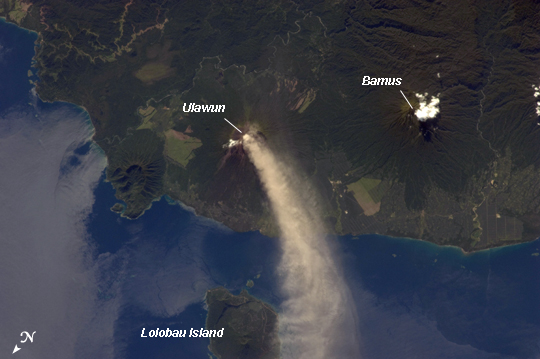 |
| Eruption at Ulawun Volcano, New Britain Island, Papua New Guinea Numerous volcanoes contribute to the landmass of the island of New Britain, the largest in the Bismarck Archipelago of Papua New Guinea. One of the most active of these volcanoes, Ulawun, is also the highest with a summit elevation of 2,334 meters. This astronaut photograph was taken during the most recent phase of volcanic activity at Ulawun. A white steam and ash plume extends from the summit crater of the stratovolcano towards the northwest (image center; note the image is oriented such that north is towards the lower left). The plume begins to broaden as it passes the southwestern coast of Lolobau Island approximately 23 kilometers downwind from its source. Ulawun volcano is also known as "the Father", with the Bamus volcano to the southwest also known as "the South Son". The summit of Bamus is obscured by white cumulus clouds (not of volcanic origin) in this image. While Ulawun has been active since at least 1700, the most recent eruptive activity at Bamus occurred in the late 19th century. A large region of ocean surface highlighted by sunglint - sunlight reflecting off the water surface, lending it a mirror-like appearance- is visible to the north-northeast of Ulawun (image lower left). |
| Images: | All Available Images Low-Resolution 164k |
|
| Mission: | ISS034 |
|
| Roll - Frame: | E - 5496 |
|
| Geographical Name: | PAPUA NEW GUINEA |
|
| Features: | ULAWUN VOLCANO, ERUPTION PLUME, BAMUS VOLCANO, LOLOBAU ISLAND |
|
| Center Lat x Lon: | 5.1S x 151.3E |
|
| Film Exposure: | N=Normal exposure, U=Under exposed, O=Over exposed, F=out of Focus |
|
| Percentage of Cloud Cover-CLDP: | 10 |
|
| Camera:: | N2 |
|
| Camera Tilt: | 27 | LO=Low Oblique, HO=High Oblique, NV=Near Vertical |
| Camera Focal Length: | 180 |
|
| Nadir to Photo Center Direction: | E | The direction from the nadir to the center point, N=North, S=South, E=East, W=West |
| Stereo?: | Y=Yes there is an adjacent picture of the same area, N=No there isn't |
|
| Orbit Number: | |
|
| Date: | 20121130 | YYYYMMDD |
| Time: | 222738 | GMT HHMMSS |
| Nadir Lat: | 4.3S |
Latitude of suborbital point of spacecraft |
| Nadir Lon: | 149.5E |
Longitude of suborbital point of spacecraft |
| Sun Azimuth: | 114 | Clockwise angle in degrees from north to the sun measured at the nadir point |
| Space Craft Altitude: | 228 | nautical miles |
| Sun Elevation: | 38 | Angle in degrees between the horizon and the sun, measured at the nadir point |
| Land Views: | COAST, CRATER, ISLAND, VOLCANO |
|
| Water Views: | OCEAN, SUNGLINT |
|
| Atmosphere Views: | PLUME |
|
| Man Made Views: | |
|
| City Views: | |
|
Photo is not associated with any sequences | ||
| NASA Home Page |
JSC Home Page |
JSC Digital Image Collection |
Earth Science & Remote Sensing |
|
This service is provided by the International Space Station program and the JSC Earth Science & Remote Sensing Unit, ARES Division, Exploration Integration Science Directorate.

|