
Geographic Region: USA-NEW YORK
Feature: LONG ISLAND,CAPE COD,SUNGLINT,BLOCK ISLAND,BUZZARDS BAY,ATMOSPHERIC LIMB
|
Geographic Region: USA-NEW YORK Feature: LONG ISLAND,CAPE COD,SUNGLINT,BLOCK ISLAND,BUZZARDS BAY,ATMOSPHERIC LIMB |
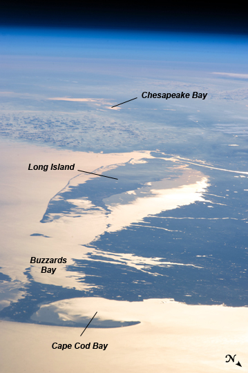 |
| Northeastern USA Coastline in Sunglint Looking out at the Earth's surface from the International Space Station (ISS), astronauts frequently observe sunglint highlighting both ocean and inland water surfaces. The Atlantic Ocean, including Cape Cod Bay and Buzzards Bay along the coastlines of the states of Massachusetts and Rhode Island has a burnished, mirror-like appearance in this image. This is due to sunlight reflected off the water surface back towards the astronaut-photographer on the ISS. The peak reflection point is towards the right side of the image, lending the waters of Long Island Sound (at image center, to the north of Long Island) and the upper Massachusetts coastline an even brighter appearance. Sunglint also illuminates surface waters of Chesapeake Bay (image top center) located over 400 km to the southwest of the tip of Long Island. This suggests that the Sun was low on the horizon due to the observed extent of the sunglint effect. The time of image acquisition, approximately 4:26 PM Eastern Standard Time confirms that the image was taken approximately 1 hour before local sunset. There is little in the image to indicate that the region was still recovering from a major winter storm which dropped almost one meter of snow over much of the northeastern USA less than one week earlier. The high viewing angle from the ISS also allows the Earth's curvature, or limb, to be seen; blue atmospheric layers gradually fade into the darkness of space across the top part of the image. Low clouds near Cape Cod, Long Island, and further down the Atlantic coastline cast shadows over the water surfaces, reducing the sunglint in some areas. |
| Images: | All Available Images Low-Resolution 173k |
|
| Mission: | ISS034 |
|
| Roll - Frame: | E - 48455 |
|
| Geographical Name: | USA-NEW YORK |
|
| Features: | LONG ISLAND,CAPE COD,SUNGLINT,BLOCK ISLAND,BUZZARDS BAY,ATMOSPHERIC LIMB |
|
| Center Lat x Lon: | 40.9N x 73.1W |
|
| Film Exposure: | N=Normal exposure, U=Under exposed, O=Over exposed, F=out of Focus |
|
| Percentage of Cloud Cover-CLDP: | 25 |
|
| Camera:: | N5 |
|
| Camera Tilt: | HO | LO=Low Oblique, HO=High Oblique, NV=Near Vertical |
| Camera Focal Length: | 400 |
|
| Nadir to Photo Center Direction: | W | The direction from the nadir to the center point, N=North, S=South, E=East, W=West |
| Stereo?: | Y=Yes there is an adjacent picture of the same area, N=No there isn't |
|
| Orbit Number: | |
|
| Date: | 20130214 | YYYYMMDD |
| Time: | 212623 | GMT HHMMSS |
| Nadir Lat: | 46.4N |
Latitude of suborbital point of spacecraft |
| Nadir Lon: | 55.3W |
Longitude of suborbital point of spacecraft |
| Sun Azimuth: | 256 | Clockwise angle in degrees from north to the sun measured at the nadir point |
| Space Craft Altitude: | 222 | nautical miles |
| Sun Elevation: | -4 | Angle in degrees between the horizon and the sun, measured at the nadir point |
| Land Views: | CAPE, ISLAND |
|
| Water Views: | BAY, OCEAN, SUNGLINT |
|
| Atmosphere Views: | |
|
| Man Made Views: | |
|
| City Views: | |
|
Photo is not associated with any sequences | ||
| NASA Home Page |
JSC Home Page |
JSC Digital Image Collection |
Earth Science & Remote Sensing |
|
This service is provided by the International Space Station program and the JSC Earth Science & Remote Sensing Unit, ARES Division, Exploration Integration Science Directorate.

|