
Geographic Region: USA-NEVADA
Feature: RENO AT NIGHT,PYRAMID LAKE,FERNLEY AT NIGHT
|
Geographic Region: USA-NEVADA Feature: RENO AT NIGHT,PYRAMID LAKE,FERNLEY AT NIGHT |
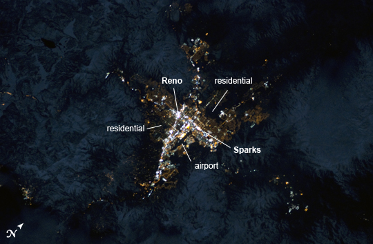 |
| Reno, Nevada Metropolitan Area at Night Note: This caption refers to the image versions labeled "NASA's Earth Observatory web site". Known as "the biggest little city in the world", the city of Reno is located in Truckee Meadows along the eastern foothills of the Sierra Nevada near the California border. It forms part of the Reno-Sparks metropolitan area--the largest such area in northern Nevada, and the second largest in the state after Las Vegas. Lake Tahoe, a major destination for skiing and other outdoor recreational activities, is located less than 50 kilometers to the southwest of the Reno-Sparks metro area. The relatively isolated nature of the metropolitan area within the surrounding terrain is highlighted in this night time image taken from the International Space Station. The major industrial and commercial areas of both Reno and Sparks are brightly lit at image center. The major street grid is visible as orange linear features adjacent to the industrial/commercial areas. Residential areas appear dark in contrast. The Reno-Tahoe International Airport (image center) is visible as a dark, dagger-shaped region in the southeast quarter of the metropolitan area. At the time this astronaut photograph was taken, the Moon was in a waning gibbous phase (98% of a full moon). Moonlight provided enough illumination of the ground surface such that the topography, accentuated by snow cover, surrounding the Reno-Sparks area is clearly visible (image upper left, lower left) following color enhancement. |
| Images: | All Available Images Low-Resolution 181k |
|
| Mission: | ISS034 |
|
| Roll - Frame: | E - 35548 |
|
| Geographical Name: | USA-NEVADA |
|
| Features: | RENO AT NIGHT,PYRAMID LAKE,FERNLEY AT NIGHT |
|
| Center Lat x Lon: | 39.5N x 119.7W |
|
| Film Exposure: | N=Normal exposure, U=Under exposed, O=Over exposed, F=out of Focus |
|
| Percentage of Cloud Cover-CLDP: | 10 |
|
| Camera:: | N5 |
|
| Camera Tilt: | 39 | LO=Low Oblique, HO=High Oblique, NV=Near Vertical |
| Camera Focal Length: | 180 |
|
| Nadir to Photo Center Direction: | W | The direction from the nadir to the center point, N=North, S=South, E=East, W=West |
| Stereo?: | Y=Yes there is an adjacent picture of the same area, N=No there isn't |
|
| Orbit Number: | |
|
| Date: | 20130128 | YYYYMMDD |
| Time: | 073531 | GMT HHMMSS |
| Nadir Lat: | 40.2N |
Latitude of suborbital point of spacecraft |
| Nadir Lon: | 116.8W |
Longitude of suborbital point of spacecraft |
| Sun Azimuth: | 345 | Clockwise angle in degrees from north to the sun measured at the nadir point |
| Space Craft Altitude: | 223 | nautical miles |
| Sun Elevation: | -67 | Angle in degrees between the horizon and the sun, measured at the nadir point |
| Land Views: | |
|
| Water Views: | |
|
| Atmosphere Views: | |
|
| Man Made Views: | AIRPORT |
|
| City Views: | RENO, SPARKS |
|
Photo is not associated with any sequences | ||
| NASA Home Page |
JSC Home Page |
JSC Digital Image Collection |
Earth Science & Remote Sensing |
|
This service is provided by the International Space Station program and the JSC Earth Science & Remote Sensing Unit, ARES Division, Exploration Integration Science Directorate.

|