Geographic Region: JAPAN
Feature: KYUSHU,SAKURAJIMA VOLCANO,PLUME,KAGOSHIMA BAY,KAGOSHIMA,KIRISHIMA
|
Geographic Region: JAPAN Feature: KYUSHU,SAKURAJIMA VOLCANO,PLUME,KAGOSHIMA BAY,KAGOSHIMA,KIRISHIMA |
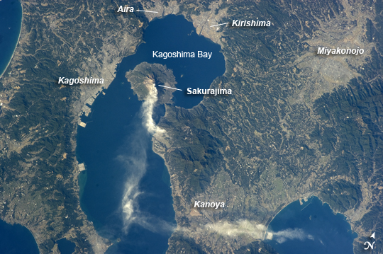 |
| Sakurajima Volcano, Kyushu, Japan This astronaut photograph taken from the International Space Station highlights Sakurajima, one of Japan's most active volcanoes (image center). There are several eruption craters near the 1,117 meter summit of Sakurajima; Kita-dake to the north last erupted approximately 5000 years ago, while Minami-dake and Showa crater to the south have been the site of frequent eruptions since at least the 8th century. The ash plume visible near the volcano summit and extending to the southeast may have originated from either Minami-dake or Showa craters. Sakurajima began forming approximately 13,000 years ago; prior to 1914, the volcano was an island in Kagoshima Bay--it was joined to the mainland by volcanic material following a major eruption in 1914. The image highlights the proximity of several large urban areas (Aira, Kagoshima, Kanoya, Kirishima, and Miyakonojo are readily visible) to Sakurajima. This has prompted studies of potential health hazards presented by the volcanic ash (Hillman et al. 2012), which are particularly important if more powerful explosive eruptive activity resumes at the volcano. The Tokyo Volcanic Ash Advisory Center (VAAC //ds.data.jma.go.jp/svd/vaac/data/index.html) of the Japan Meteorological Agency issues advisories when eruptions occur. An advisory on the activity captured in this image was issued less than one hour before the astronaut took the photograph, by which time the plume tail had encountered northeast-trending upper-level winds (image bottom center). Reference: Hillman, S.E., Horwell, C.J., Densmore, A.L., Damby, D.E., Fubini, B., Ishimine, Y., and Tomatis, M. (2012) Sakurajima volcano: a physico-chemical study of the health consequences of long-term exposure to volcanic ash, Bulletin of Volcanology, 74:913-930 (DOI: 10.1007/s00445-012-0575-3). |
| Images: | All Available Images Low-Resolution 277k |
|
| Mission: | ISS034 |
|
| Roll - Frame: | E - 27139 |
|
| Geographical Name: | JAPAN |
|
| Features: | KYUSHU,SAKURAJIMA VOLCANO,PLUME,KAGOSHIMA BAY,KAGOSHIMA,KIRISHIMA |
|
| Center Lat x Lon: | 31.5N x 130.8E |
|
| Film Exposure: | N=Normal exposure, U=Under exposed, O=Over exposed, F=out of Focus |
|
| Percentage of Cloud Cover-CLDP: | 10 |
|
| Camera:: | N5 |
|
| Camera Tilt: | 39 | LO=Low Oblique, HO=High Oblique, NV=Near Vertical |
| Camera Focal Length: | 180 |
|
| Nadir to Photo Center Direction: | N | The direction from the nadir to the center point, N=North, S=South, E=East, W=West |
| Stereo?: | Y=Yes there is an adjacent picture of the same area, N=No there isn't |
|
| Orbit Number: | |
|
| Date: | 20130110 | YYYYMMDD |
| Time: | 054348 | GMT HHMMSS |
| Nadir Lat: | 28.7N |
Latitude of suborbital point of spacecraft |
| Nadir Lon: | 131.5E |
Longitude of suborbital point of spacecraft |
| Sun Azimuth: | 218 | Clockwise angle in degrees from north to the sun measured at the nadir point |
| Space Craft Altitude: | 214 | nautical miles |
| Sun Elevation: | 29 | Angle in degrees between the horizon and the sun, measured at the nadir point |
| Land Views: | CRATER, ISLAND, VOLCANO |
|
| Water Views: | BAY |
|
| Atmosphere Views: | PLUME |
|
| Man Made Views: | |
|
| City Views: | KAGOSHIMA |
|
Photo is not associated with any sequences | ||
| NASA Home Page |
JSC Home Page |
JSC Digital Image Collection |
Earth Science & Remote Sensing |
|
This service is provided by the International Space Station program and the JSC Earth Science & Remote Sensing Unit, ARES Division, Exploration Integration Science Directorate.

|