Geographic Region: CHINA
Feature: AGR. FIELDS UNDER SNOW, SONGHUA R.
|
Geographic Region: CHINA Feature: AGR. FIELDS UNDER SNOW, SONGHUA R. |
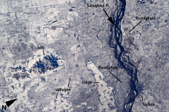 |
| Agricultural Fields Under Snow, Easternmost China This astronaut photograph highlights many hundreds of rectangular fields on either side of a 36-km stretch of the braided Songhua River (image right). Some fields are easier to see than others due to the winter snow cover. The Songhua joins with the Amur R. about 40 km downstream, at the border with Russia's Far East. Numerous villages also appear as small gray polygons. Broad floodplains can be recognized on both sides of the river, occupied by fewer fields by almost no villages. The town of Suibing stands out as a larger gray patch on the banks of the river. A significant 300 m-high hill south of the river throws midmorning shadows (image left). The region is one of the most heavily cultivated in northeastern China with corn, soybeans, and sorghum being major crops. The areas of varying whiteness of the snow cover may correlate with zones of different crops and forest cover (for example, on the hill in the center part of the image). The degree to which fallow fields are cleared of vegetation may also affect the apparent snow brightness. |
| Images: | All Available Images Low-Resolution 269k |
|
| Mission: | ISS033 |
|
| Roll - Frame: | E - 22759 |
|
| Geographical Name: | CHINA |
|
| Features: | AGR. FIELDS UNDER SNOW, SONGHUA R. |
|
| Center Lat x Lon: | 47.1N x 131.6E |
|
| Film Exposure: | N=Normal exposure, U=Under exposed, O=Over exposed, F=out of Focus |
|
| Percentage of Cloud Cover-CLDP: | 10 |
|
| Camera:: | N5 |
|
| Camera Tilt: | 27 | LO=Low Oblique, HO=High Oblique, NV=Near Vertical |
| Camera Focal Length: | 400 |
|
| Nadir to Photo Center Direction: | NE | The direction from the nadir to the center point, N=North, S=South, E=East, W=West |
| Stereo?: | Y=Yes there is an adjacent picture of the same area, N=No there isn't |
|
| Orbit Number: | |
|
| Date: | 20121118 | YYYYMMDD |
| Time: | 010111 | GMT HHMMSS |
| Nadir Lat: | 46.0N |
Latitude of suborbital point of spacecraft |
| Nadir Lon: | 130.0E |
Longitude of suborbital point of spacecraft |
| Sun Azimuth: | 149 | Clockwise angle in degrees from north to the sun measured at the nadir point |
| Space Craft Altitude: | 225 | nautical miles |
| Sun Elevation: | 19 | Angle in degrees between the horizon and the sun, measured at the nadir point |
| Land Views: | HILL |
|
| Water Views: | RIVER |
|
| Atmosphere Views: | |
|
| Man Made Views: | |
|
| City Views: | |
|
Photo is not associated with any sequences | ||
| NASA Home Page |
JSC Home Page |
JSC Digital Image Collection |
Earth Science & Remote Sensing |
|
This service is provided by the International Space Station program and the JSC Earth Science & Remote Sensing Unit, ARES Division, Exploration Integration Science Directorate.

|