
Geographic Region: USA-TEXAS
Feature: DALLAS AT NIGHT,CARROLLTON AT NIGHT,RICHARDSON AT NIGHT
|
Geographic Region: USA-TEXAS Feature: DALLAS AT NIGHT,CARROLLTON AT NIGHT,RICHARDSON AT NIGHT |
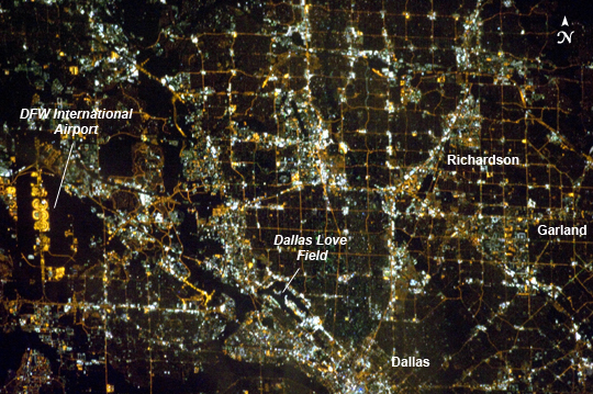 |
| Dallas, Texas Metropolitan Area at Night Most metropolitan areas of the western United States are configured over large areas with a regular street grid pattern that is highly recognizable from space, particularly at night. The northern Dallas, TX metropolitan area exhibits this pattern, visible in this astronaut photograph taken from the International Space Station. The north-south and east-west grid pattern of major surface streets is highlighted by orange street lighting, lending a fishnet-like appearance to the urban area. Within this framework, smaller residential and commercial buildings and streets give green-gray stipple patterns to some blocks. The airplane terminals of Dallas-Fort Worth International Airport are lit with golden-yellow lights, and surrounded by relatively dark runways and fields at image left. Likewise, the runways of Dallas Love Field at image lower center are recognizable by their darkness. Other dark areas within the metro region are open space, parks, and water bodies. Larger commercial areas, public and industrial facilities appear as brilliantly like regions and points throughout the image. Dallas is part of the larger Dallas-Fort Worth-Arlington Metropolitan Statistical Area (population 6,526,548 in 2011) as recognized by the U.S. Census Bureau; to most Texans, it is simply "DFW" or "the Metroplex". Several of the larger urban areas within DFW are visible in this image; Dallas, Garland and Richardson all have populations above 100,000 according to the North Central Texas Council of Governments. While historically the economy of Dallas was based in the oil and cotton industries, today commerce, technology, healthcare, and transportation are the major economic drivers. |
| Images: | Images: | NO IMAGES YET | |||
| Mission: | ISS033 |
||||
| Roll - Frame: | E - 21663 |
||||
| Geographical Name: | USA-TEXAS |
||||
| Features: | DALLAS AT NIGHT,CARROLLTON AT NIGHT,RICHARDSON AT NIGHT |
||||
| Center Lat x Lon: | 32.9N x 96.8W |
||||
| Film Exposure: | N=Normal exposure, U=Under exposed, O=Over exposed, F=out of Focus |
||||
| Percentage of Cloud Cover-CLDP: | 0 |
||||
| Camera:: | N5 |
||||
| Camera Tilt: | 34 | LO=Low Oblique, HO=High Oblique, NV=Near Vertical |
|||
| Camera Focal Length: | 400 |
||||
| Nadir to Photo Center Direction: | SW | The direction from the nadir to the center point, N=North, S=South, E=East, W=West |
|||
| Stereo?: | Y=Yes there is an adjacent picture of the same area, N=No there isn't |
||||
| Orbit Number: | |
||||
| Date: | 20121115 | YYYYMMDD |
|||
| Time: | 105336 | GMT HHMMSS |
|||
| Nadir Lat: | 34.8N |
Latitude of suborbital point of spacecraft | |||
| Nadir Lon: | 95.1W |
Longitude of suborbital point of spacecraft | |||
| Sun Azimuth: | 96 | Clockwise angle in degrees from north to the sun measured at the nadir point |
|||
| Space Craft Altitude: | 223 | nautical miles |
|||
| Sun Elevation: | -25 | Angle in degrees between the horizon and the sun, measured at the nadir point |
|||
| Land Views: | |
||||
| Water Views: | |
||||
| Atmosphere Views: | |
||||
| Man Made Views: | AIRPORT, URBAN AREA |
||||
| City Views: | ARLINGTON, DALLAS, FORT WORTH |
||||
Photo is not associated with any sequences | |||||
| NASA Home Page |
JSC Home Page |
JSC Digital Image Collection |
Earth Science & Remote Sensing |
|
This service is provided by the International Space Station program and the JSC Earth Science & Remote Sensing Unit, ARES Division, Exploration Integration Science Directorate.

|