
Geographic Region: SAUDI ARABIA
Feature: RIYADH AT NIGHT
|
Geographic Region: SAUDI ARABIA Feature: RIYADH AT NIGHT |
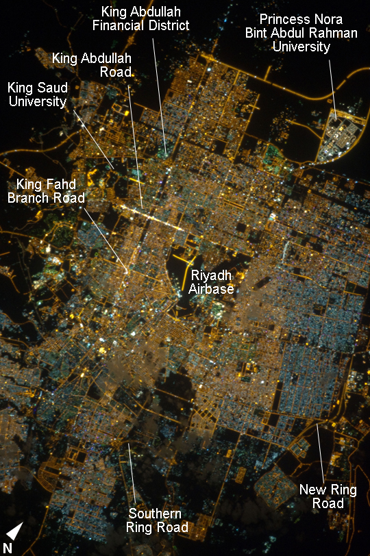 |
| Riyadh, Saudi Arabia, at Night Note: This caption refers to the image versions labeled "NASA's Earth Observatory web site". The population of Riyadh, the capital city of Saudi Arabia, has risen dramatically in the last half century, from 150,000 in 1960 to an estimated 5.4 million in 2012. The city appears as a brightly colored patchwork in this night time astronaut photograph. The brightest lights, apart from those on the old Riyadh Airbase at image center (the new international airport is far outside the city and not shown here), follow the commercial districts along King Abdullah Road and King Fahd Branch Road. Many of the darker patches within the built area are city parks. University sectors stand out with different street and light patterns, as seen in the King Saud University campus which houses the Arabic Language Institute, and the Princess Nora Bint Abdul Rahman University which is the largest all-female university in the world. Highways and various ring roads also stand out in night imagery due to bright regular lighting. Lighted developments beyond the ring roads mark the growth of the city (image lower left and lower right). Newer neighborhoods, set further from the city center, are recognizable by blue-gray lightning (ex. image right). |
| Images: | All Available Images Low-Resolution 596k |
|
| Mission: | ISS033 |
|
| Roll - Frame: | E - 20288 |
|
| Geographical Name: | SAUDI ARABIA |
|
| Features: | RIYADH AT NIGHT |
|
| Center Lat x Lon: | 24.8N x 46.7E |
|
| Film Exposure: | N=Normal exposure, U=Under exposed, O=Over exposed, F=out of Focus |
|
| Percentage of Cloud Cover-CLDP: | 10 |
|
| Camera:: | N5 |
|
| Camera Tilt: | 06 | LO=Low Oblique, HO=High Oblique, NV=Near Vertical |
| Camera Focal Length: | 400 |
|
| Nadir to Photo Center Direction: | E | The direction from the nadir to the center point, N=North, S=South, E=East, W=West |
| Stereo?: | Y=Yes there is an adjacent picture of the same area, N=No there isn't |
|
| Orbit Number: | |
|
| Date: | 20121113 | YYYYMMDD |
| Time: | 013748 | GMT HHMMSS |
| Nadir Lat: | 24.9N |
Latitude of suborbital point of spacecraft |
| Nadir Lon: | 46.3E |
Longitude of suborbital point of spacecraft |
| Sun Azimuth: | 101 | Clockwise angle in degrees from north to the sun measured at the nadir point |
| Space Craft Altitude: | 224 | nautical miles |
| Sun Elevation: | -21 | Angle in degrees between the horizon and the sun, measured at the nadir point |
| Land Views: | |
|
| Water Views: | |
|
| Atmosphere Views: | |
|
| Man Made Views: | |
|
| City Views: | RIYADH |
|
Photo is not associated with any sequences | ||
| NASA Home Page |
JSC Home Page |
JSC Digital Image Collection |
Earth Science & Remote Sensing |
|
This service is provided by the International Space Station program and the JSC Earth Science & Remote Sensing Unit, ARES Division, Exploration Integration Science Directorate.

|