
Geographic Region: DOMINICAN REPUBLIC
Feature: PAN-HISPANIOLA, TURKS & CAICOS IS., HAZE
|
Geographic Region: DOMINICAN REPUBLIC Feature: PAN-HISPANIOLA, TURKS & CAICOS IS., HAZE |
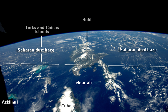 |
| Saharan Dust Reaches the Americas Weather satellites frequently document major dust palls blowing from the Sahara Desert westward from Africa out into the tropical Atlantic Ocean. Astronauts frequently see these Saharan dust masses as very widespread atmospheric haze. Dust palls blowing from Africa can be transported right across the Atlantic Ocean. It takes about a week to reach either North America (in northern hemisphere summer) or South America (in northern hemisphere winter). This puts the Caribbean basin on the receiving end of many of these events. Recently, researchers have linked Saharan dust to coral disease, allergic reactions in humans, and red tides. The margin of the hazy air in this image, taken recently by astronauts on board the International Space Station (ISS), reaches as far as Haiti (image center) and the nearby Turks and Caicos Islands (image left) - but the eastern tip of Cuba in the foreground remains in the clear air. This image attracted the eye of scientists at the Johnson Space Center because the margin between the dust haze and the clear atmosphere lies in almost the same location as it appears in another astronaut image, also taken in mid-July, but nearly twenty years ago (in 1994) by astronauts aboard the Space Shuttle Columbia. In 1994, few scientists had considered the possibility of transatlantic dust transport. It may be surprising that the dust is still visible in the downwind hemisphere thousands of kilometers from its origin, here probably almost 8000 km from its likely source in northern Mali--although data from sensors such as NASA's TOMS (Total Ozone Mapping Spectrometer) and OMI (Ozone Monitoring Instrument) have suggested that some dust transported across the Atlantic may have originated further east in Chad or Sudan. We now know that African dust reaches the western hemisphere every month of the year, not necessarily in as highly a visible form as in these images. Also, there is evidence that some of this African dust even serves as a source of airborne nutrients for Amazon rainforest vegetation. Saharan dust is known on occasion to reach all the way into the Pacific Ocean, crossing Mexico at the narrow Isthmus of Tehuantepec. |
| Images: | All Available Images Low-Resolution 219k |
|
| Mission: | ISS032 |
|
| Roll - Frame: | E - 8976 |
|
| Geographical Name: | DOMINICAN REPUBLIC |
|
| Features: | PAN-HISPANIOLA, TURKS & CAICOS IS., HAZE |
|
| Center Lat x Lon: | 18.5N x 71W |
|
| Film Exposure: | N=Normal exposure, U=Under exposed, O=Over exposed, F=out of Focus |
|
| Percentage of Cloud Cover-CLDP: | 25 |
|
| Camera:: | N5 |
|
| Camera Tilt: | HO | LO=Low Oblique, HO=High Oblique, NV=Near Vertical |
| Camera Focal Length: | 28 |
|
| Nadir to Photo Center Direction: | E | The direction from the nadir to the center point, N=North, S=South, E=East, W=West |
| Stereo?: | Y=Yes there is an adjacent picture of the same area, N=No there isn't |
|
| Orbit Number: | |
|
| Date: | 20120715 | YYYYMMDD |
| Time: | 190914 | GMT HHMMSS |
| Nadir Lat: | 19.3N |
Latitude of suborbital point of spacecraft |
| Nadir Lon: | 78W |
Longitude of suborbital point of spacecraft |
| Sun Azimuth: | 280 | Clockwise angle in degrees from north to the sun measured at the nadir point |
| Space Craft Altitude: | 212 | nautical miles |
| Sun Elevation: | 64 | Angle in degrees between the horizon and the sun, measured at the nadir point |
| Land Views: | DESERT |
|
| Water Views: | OCEAN |
|
| Atmosphere Views: | DUST, HAZE |
|
| Man Made Views: | |
|
| City Views: | |
|
Photo is not associated with any sequences | ||
| NASA Home Page |
JSC Home Page |
JSC Digital Image Collection |
Earth Science & Remote Sensing |
|
This service is provided by the International Space Station program and the JSC Earth Science & Remote Sensing Unit, ARES Division, Exploration Integration Science Directorate.

|