
Geographic Region: RUSSIAN FEDERATION
Feature: KRYMSK,FLOODING,AGRICULTURE,URBAN AREA
|
Geographic Region: RUSSIAN FEDERATION Feature: KRYMSK,FLOODING,AGRICULTURE,URBAN AREA |
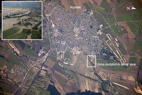 |
| Flooding in Krymsk, Krasnodar region, Southern Russia Note: This caption refers to the image versions labeled "NASA's Earth Observatory web site". On the night of July 7, 2012 a major storm dumped more than a foot of water on the southern Russian area of Krasnodar, near the Black Sea. The resulting flood was likened to a tsunami, and to date, more than 170 people died, most from the city of Krymsk. The Moscow times reports that more than 19,000 people lost everything. This image taken by cosmonauts aboard the International Space Station shows the city of Krymsk. For context, an aerial view (inset) that was posted in the Moscow Times shows the flooding of the Kuban River tributary that flows through the center of the city, three days before the astronaut photograph was taken - the box denotes the area represented by that photo. Regions that were flooded along the channel have tan to brown coloration in the astronaut photograph. The color is probably due to the mud and debris that was left behind by the floodwaters. Krymsk is located in the western foothills on the northern slope of the Caucasus Mountains--a range that stretches between the Black Sea and the Caspian Sea. The vast amount of rain quickly overwhelmed the small river channels that flow northward from the mountains to the Russian lowlands and the Kuban River; Krymsk, located on one of those tributaries, was directly in the pathway of the flash flood. As part of the international partner agreement to use the International Space Station to benefit humanity, crew members and other Earth observing instruments provide best-effort support to the International Disaster Charter (IDC) when it is activated by collecting imagery of areas on the ground impacted by natural events such as the flooding in Krymsk. This image was acquired July 10, 2012 in response to the IDC activation. Collected data may be used by relief efforts, or to communicate more clearly the geographic impacts of activation events through annotated maps. |
| Images: | All Available Images Low-Resolution 339k |
|
| Mission: | ISS032 |
|
| Roll - Frame: | E - 6129 |
|
| Geographical Name: | RUSSIAN FEDERATION |
|
| Features: | KRYMSK,FLOODING,AGRICULTURE,URBAN AREA |
|
| Center Lat x Lon: | 44.9N x 38.0E |
|
| Film Exposure: | N=Normal exposure, U=Under exposed, O=Over exposed, F=out of Focus |
|
| Percentage of Cloud Cover-CLDP: | 10 |
|
| Camera:: | N4 |
|
| Camera Tilt: | 08 | LO=Low Oblique, HO=High Oblique, NV=Near Vertical |
| Camera Focal Length: | 1200 |
|
| Nadir to Photo Center Direction: | SE | The direction from the nadir to the center point, N=North, S=South, E=East, W=West |
| Stereo?: | Y=Yes there is an adjacent picture of the same area, N=No there isn't |
|
| Orbit Number: | |
|
| Date: | 20120710 | YYYYMMDD |
| Time: | 061256 | GMT HHMMSS |
| Nadir Lat: | 45.2N |
Latitude of suborbital point of spacecraft |
| Nadir Lon: | 37.6E |
Longitude of suborbital point of spacecraft |
| Sun Azimuth: | 102 | Clockwise angle in degrees from north to the sun measured at the nadir point |
| Space Craft Altitude: | 211 | nautical miles |
| Sun Elevation: | 43 | Angle in degrees between the horizon and the sun, measured at the nadir point |
| Land Views: | RANGE |
|
| Water Views: | CHANNEL, FLOODING, RIVER |
|
| Atmosphere Views: | |
|
| Man Made Views: | |
|
| City Views: | MOSCOW |
|
Photo is not associated with any sequences | ||
| NASA Home Page |
JSC Home Page |
JSC Digital Image Collection |
Earth Science & Remote Sensing |
|
This service is provided by the International Space Station program and the JSC Earth Science & Remote Sensing Unit, ARES Division, Exploration Integration Science Directorate.

|