
Geographic Region: TURKEY
Feature: ISTANBUL AT NIGHT
|
Geographic Region: TURKEY Feature: ISTANBUL AT NIGHT |
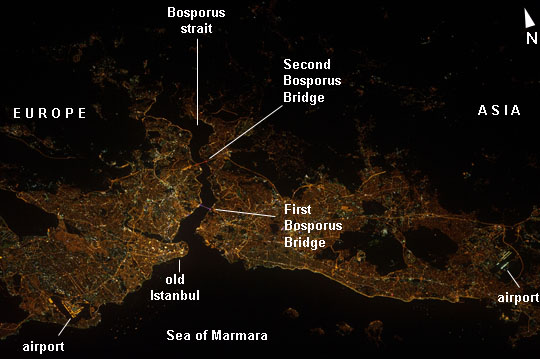 |
| Istanbul, Turkey at Night Most of Istanbul's Asian suburbs (image right) appear in this night view from the International Space Station, but only about half the area of the city on the European side (image left) can be seen. The margins of the metropolitan area are clearly visible at night, more so than in daylight images. The Bosporus strait (also spelled Bosphorus) (image center left) famously separates the two halves of the city, and links the small Sea of Marmara (and the Mediterranean Sea to its south) to the Black Sea (indistinguishable in this night view, top right). The strait is 31 km long, most of which is visible in this view. The Bosporus is a very busy waterway, with larger ships passing to and from the Black Sea competing with numerous ferries that cross between the two halves of the city. Apart from the dark Sea of Marmara (lower margin of the image), the other large dark areas are all wooded hills which provide open spaces for the densely populated city of Istanbul - one of the largest in Europe with 13.5 million inhabitants. The old city occupies the prominent point at the entrance to the strait. Major traffic arteries are the brighter lines crossing the metropolitan area, and also mark all the shorelines. The First Bosporus Bridge and Second Bridge (also known as the Fatih Sultan Mehmet Bridge) can be seen spanning the strait. The brilliant lights of both international airports serving the region also stand out at image lower left and image lower right. |
| Images: | All Available Images Low-Resolution 88k |
|
| Mission: | ISS032 |
|
| Roll - Frame: | E - 17547 |
|
| Geographical Name: | TURKEY |
|
| Features: | ISTANBUL AT NIGHT |
|
| Center Lat x Lon: | 41.1N x 29.1E |
|
| Film Exposure: | N=Normal exposure, U=Under exposed, O=Over exposed, F=out of Focus |
|
| Percentage of Cloud Cover-CLDP: | 10 |
|
| Camera:: | N5 |
|
| Camera Tilt: | 45 | LO=Low Oblique, HO=High Oblique, NV=Near Vertical |
| Camera Focal Length: | 400 |
|
| Nadir to Photo Center Direction: | SW | The direction from the nadir to the center point, N=North, S=South, E=East, W=West |
| Stereo?: | Y=Yes there is an adjacent picture of the same area, N=No there isn't |
|
| Orbit Number: | |
|
| Date: | 20120809 | YYYYMMDD |
| Time: | 233820 | GMT HHMMSS |
| Nadir Lat: | 43.6N |
Latitude of suborbital point of spacecraft |
| Nadir Lon: | 31.6E |
Longitude of suborbital point of spacecraft |
| Sun Azimuth: | 27 | Clockwise angle in degrees from north to the sun measured at the nadir point |
| Space Craft Altitude: | 214 | nautical miles |
| Sun Elevation: | -27 | Angle in degrees between the horizon and the sun, measured at the nadir point |
| Land Views: | |
|
| Water Views: | SEA, STRAIT |
|
| Atmosphere Views: | |
|
| Man Made Views: | BRIDGE |
|
| City Views: | ISTANBUL |
|
Photo is not associated with any sequences | ||
| NASA Home Page |
JSC Home Page |
JSC Digital Image Collection |
Earth Science & Remote Sensing |
|
This service is provided by the International Space Station program and the JSC Earth Science & Remote Sensing Unit, ARES Division, Exploration Integration Science Directorate.

|