
Geographic Region: USA-NEVADA
Feature: WALKER LAKE,HAWTHORNE,AGRICULTURAL FIELDS,MOUNT GRANT
|
Geographic Region: USA-NEVADA Feature: WALKER LAKE,HAWTHORNE,AGRICULTURAL FIELDS,MOUNT GRANT |
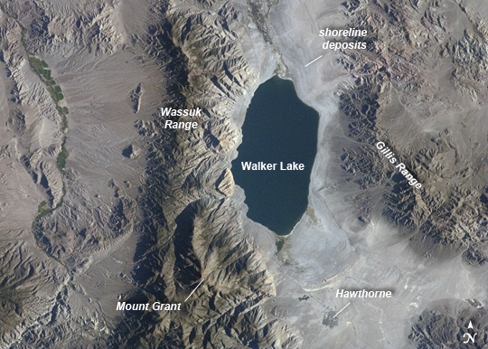 |
| Walker Lake, Nevada Note: This caption refers to the image versions labeled "NASA's Earth Observatory web site". The Pleistocene landscape of western Nevada approximately 15,000 years ago was one of narrow mountain ranges and numerous interconnected lakes that together formed the extensive glacial Lake Lahontan. Drying and warming of the regional climate since the last Ice Age led to the disappearance of the glaciers feeding meltwater to Lake Lahontan, and eventual disappearance of the lake itself. Today, few remnants of Lahontan remain; most of its arms have become dry enclosed basins known as playas. This astronaut photograph highlights Walker Lake, one of only two remnant lakes that contain water throughout the year (Pyramid Lake in Nevada is the other). Walker Lake is located in an enclosed basin bounded by the Wassuk Range to the west and the Gillis Range to the east. The lake is fed by the Walker River flowing from the north. The current dimensions of the lake are approximately 21 kilometers north-south by 9 km east-west. Shoreline deposits at higher elevations than the current lake level form concentric bands that are just visible in the image (top center) - these record varying lake levels in the geologic past. The nearest town to Walker Lake is Hawthorne, Nevada to the southeast. To the southwest the highest peak of the Wassuk Range, Mount Grant (elevation 3496 meters above sea level), dominates the skyline. Green agricultural fields, primarily alfalfa, located to the west of the Wassuk Range (image upper left) provide a striking contrast to the surrounding Great Basin desert. These fields are irrigated using water from the nearby East Fork of the Walker River (image left, just visible alongside the fields). |
| Images: | All Available Images Low-Resolution 292k |
|
| Mission: | ISS032 |
|
| Roll - Frame: | E - 10487 |
|
| Geographical Name: | USA-NEVADA |
|
| Features: | WALKER LAKE,HAWTHORNE,AGRICULTURAL FIELDS,MOUNT GRANT |
|
| Center Lat x Lon: | 38.7N x 118.8W |
|
| Film Exposure: | N=Normal exposure, U=Under exposed, O=Over exposed, F=out of Focus |
|
| Percentage of Cloud Cover-CLDP: | 10 |
|
| Camera:: | N2 |
|
| Camera Tilt: | 23 | LO=Low Oblique, HO=High Oblique, NV=Near Vertical |
| Camera Focal Length: | 180 |
|
| Nadir to Photo Center Direction: | S | The direction from the nadir to the center point, N=North, S=South, E=East, W=West |
| Stereo?: | Y=Yes there is an adjacent picture of the same area, N=No there isn't |
|
| Orbit Number: | |
|
| Date: | 20120729 | YYYYMMDD |
| Time: | 143903 | GMT HHMMSS |
| Nadir Lat: | 40.2N |
Latitude of suborbital point of spacecraft |
| Nadir Lon: | 118.7W |
Longitude of suborbital point of spacecraft |
| Sun Azimuth: | 81 | Clockwise angle in degrees from north to the sun measured at the nadir point |
| Space Craft Altitude: | 215 | nautical miles |
| Sun Elevation: | 19 | Angle in degrees between the horizon and the sun, measured at the nadir point |
| Land Views: | BASIN, DESERT |
|
| Water Views: | LAKE, RIVER, SEA |
|
| Atmosphere Views: | |
|
| Man Made Views: | |
|
| City Views: | |
|
Photo is not associated with any sequences | ||
| NASA Home Page |
JSC Home Page |
JSC Digital Image Collection |
Earth Science & Remote Sensing |
|
This service is provided by the International Space Station program and the JSC Earth Science & Remote Sensing Unit, ARES Division, Exploration Integration Science Directorate.

|