
Geographic Region: USA-CALIFORNIA
Feature: SUTTER BUTTES, OROVILLE,COLUSA,WILLIAMS,AGRICULTURAL FIELDS
|
Geographic Region: USA-CALIFORNIA Feature: SUTTER BUTTES, OROVILLE,COLUSA,WILLIAMS,AGRICULTURAL FIELDS |
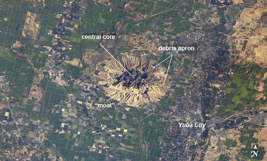 |
| Sutter Buttes, California Note: This caption refers to the image versions labeled "NASA's Earth Observatory web site". Sometimes called the "smallest mountain range in the world", the Sutter Buttes rise almost 610 meters above the surrounding flat agricultural fields of the Great Valley of central California. The Sutter Buttes are remnants of a volcano that was active approximately 1.6 - 1.4 million years ago during the Pleistocene Epoch. The central core of the Buttes is characterized by lava domes -piles of viscous lava that erupted onto the surface, building higher with each successive layer. Today, these lava domes form the high central hills of the Buttes; shadows cast by the hills are visible at image center. Surrounding the central core is an apron of fragmental material created by occasional eruptions of the lava domes - this apron extends roughly 18 km east-west and 16 km north-south. The volcanic material was transported outwards from the central core during eruptions by hot gasses (pyroclastic flows) or by cooler water-driven flows (lahars). Later stream erosion of the debris apron is evident from the radial drainage pattern surrounding the central core. A third geomorphic region of valleys known as the "moat" is present between the core and the debris apron, and was formed from erosion of older, exposed sedimentary rocks that underlie the volcanic rocks. The Sutter Buttes present a striking visual contrast with the surrounding green agricultural fields--here mostly rice, with some sunflower, winter wheat, tomato, and almonds--of the Great Valley. Urban areas such as Yuba City, CA (located 18 km to the southeast) appear as light to dark gray stippled regions. Sacramento, CA (not shown) is located approximately 80 km to the south-southeast. The image appears slightly distorted (oblique) due to the viewing angle from the International Space Station. |
| Images: | All Available Images Low-Resolution 270k |
|
| Mission: | ISS032 |
|
| Roll - Frame: | E - 10482 |
|
| Geographical Name: | USA-CALIFORNIA |
|
| Features: | SUTTER BUTTES, OROVILLE,COLUSA,WILLIAMS,AGRICULTURAL FIELDS |
|
| Center Lat x Lon: | 39.3N x 121.9W |
|
| Film Exposure: | N=Normal exposure, U=Under exposed, O=Over exposed, F=out of Focus |
|
| Percentage of Cloud Cover-CLDP: | 10 |
|
| Camera:: | N2 |
|
| Camera Tilt: | 38 | LO=Low Oblique, HO=High Oblique, NV=Near Vertical |
| Camera Focal Length: | 180 |
|
| Nadir to Photo Center Direction: | S | The direction from the nadir to the center point, N=North, S=South, E=East, W=West |
| Stereo?: | Y=Yes there is an adjacent picture of the same area, N=No there isn't |
|
| Orbit Number: | |
|
| Date: | 20120729 | YYYYMMDD |
| Time: | 143813 | GMT HHMMSS |
| Nadir Lat: | 42.1N |
Latitude of suborbital point of spacecraft |
| Nadir Lon: | 122W |
Longitude of suborbital point of spacecraft |
| Sun Azimuth: | 80 | Clockwise angle in degrees from north to the sun measured at the nadir point |
| Space Craft Altitude: | 215 | nautical miles |
| Sun Elevation: | 17 | Angle in degrees between the horizon and the sun, measured at the nadir point |
| Land Views: | EROSION, RANGE, VALLEY, VOLCANO |
|
| Water Views: | |
|
| Atmosphere Views: | |
|
| Man Made Views: | |
|
| City Views: | SACRAMENTO |
|
Photo is not associated with any sequences | ||
| NASA Home Page |
JSC Home Page |
JSC Digital Image Collection |
Earth Science & Remote Sensing |
|
This service is provided by the International Space Station program and the JSC Earth Science & Remote Sensing Unit, ARES Division, Exploration Integration Science Directorate.

|