
Geographic Region: USA-UTAH
Feature: LAKE POWELL, THE RINCON, GLEN CANYON, SUNGLINT
|
Geographic Region: USA-UTAH Feature: LAKE POWELL, THE RINCON, GLEN CANYON, SUNGLINT |
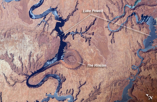 |
| Lake Powell and The Rincon, Utah This astronaut photograph highlights part of Lake Powell; the lake extends across southeastern Utah and northeastern Arizona. Lake Powell started filling in 1963 when the Glen Canyon Dam on the Colorado River in Arizona was completed, and Glen Canyon flooded. The serpentine water surface of the reservoir-highlighted by gray regions of sunglint-follows the incised course of the canyon. Today Lake Powell is part of the Glen Canyon National Recreation Area which extends for more than 186 miles along the shoreline and side canyons. The primary intended use of Lake Powell's water is support of agricultural production, with a small portion allocated to urban use in Arizona, Nevada, and California. The reservoir did not reach its maximum capacity of 27 million acre-feet until 1980. More recently, extended drought conditions in the southwestern United States over the past decade have resulted in a significant lowering of the Lake water level and emergence of parts of Glen Canyon. Should average precipitation in the Colorado River watershed lessen (as predicted by regional climate change models), that could result in further lowering of the Lake Powell water level and changes to the current water management plans. Fluctuations in water levels and change of river courses are a common occurrence seen in the geologic record of rivers. Looking somewhat like a donut or automobile tire from the vantage point of the International Space Station, The Rincon (image center) is an entrenched and abandoned meander, or loop, of the Colorado River, though to have formed several thousand years ago when the river cut straight across the ends of the loop and shortened its course by six miles. The resulting canyon and 600 - 750 feet-high central mesa indicate where the river used to flow. The term "rincon" also is used by geomorphologists to describe similar ancient river features observed elsewhere. The Goosenecks of the San Juan River are an example of an active entrenched meander. |
| Images: | All Available Images Low-Resolution 288k |
|
| Mission: | ISS031 |
|
| Roll - Frame: | E - 6398 |
|
| Geographical Name: | USA-UTAH |
|
| Features: | LAKE POWELL, THE RINCON, GLEN CANYON, SUNGLINT |
|
| Center Lat x Lon: | 37.3N x 110.8W |
|
| Film Exposure: | N=Normal exposure, U=Under exposed, O=Over exposed, F=out of Focus |
|
| Percentage of Cloud Cover-CLDP: | 0 |
|
| Camera:: | N2 |
|
| Camera Tilt: | 44 | LO=Low Oblique, HO=High Oblique, NV=Near Vertical |
| Camera Focal Length: | 400 |
|
| Nadir to Photo Center Direction: | S | The direction from the nadir to the center point, N=North, S=South, E=East, W=West |
| Stereo?: | Y=Yes there is an adjacent picture of the same area, N=No there isn't |
|
| Orbit Number: | |
|
| Date: | 20120430 | YYYYMMDD |
| Time: | 192619 | GMT HHMMSS |
| Nadir Lat: | 40.4N |
Latitude of suborbital point of spacecraft |
| Nadir Lon: | 109.4W |
Longitude of suborbital point of spacecraft |
| Sun Azimuth: | 187 | Clockwise angle in degrees from north to the sun measured at the nadir point |
| Space Craft Altitude: | 212 | nautical miles |
| Sun Elevation: | 65 | Angle in degrees between the horizon and the sun, measured at the nadir point |
| Land Views: | |
|
| Water Views: | LAKE, RESERVOIR, RIVER, SUNGLINT |
|
| Atmosphere Views: | |
|
| Man Made Views: | DAM |
|
| City Views: | SAN JUAN |
|
Photo is not associated with any sequences | ||
| NASA Home Page |
JSC Home Page |
JSC Digital Image Collection |
Earth Science & Remote Sensing |
|
This service is provided by the International Space Station program and the JSC Earth Science & Remote Sensing Unit, ARES Division, Exploration Integration Science Directorate.

|