Geographic Region: RUSSIAN FEDERATION
Feature: ALAID VOLCANO,SUNGLINT,SEA OF OKHOTSK
|
Geographic Region: RUSSIAN FEDERATION Feature: ALAID VOLCANO,SUNGLINT,SEA OF OKHOTSK |
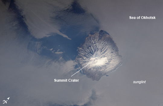 |
| Alaid Volcano, Kuril Islands, Russian Federation Note: This caption refers to the image versions labeled "NASA's Earth Observatory web site". This astronaut photograph highlights Alaid Volcano in the Kuril Islands. The Kurils chain extends from the Kamchatka Peninsula to the islands of Japan, and contains numerous active volcanoes along its length. Alaid is the highest (2339 meters above sea level) volcano in the Kuril chain, as well as being the northernmost. The textbook conic morphology of this stratovolcano is marred only by the summit crater, which is breached to the south (image center) and highlighted by snow cover. The volcano rises 3000 meters directly from the floor of the Sea of Okhotsk, with the uppermost part of the volcanic edifice exposed as an island. Much of the sea surface surrounding the volcano has a silver-gray appearance. This mirror-like appearance is due to sunglint, where light reflects off the sea surface and is scattered directly towards the astronaut observer on board the International Space Station. Sunglint is largely absent from a zone directly to the west of the volcano, most likely due to surface wind or water current patterns that change the roughness--and light scattering properties--of the water surface in this area. Volcanoes in the Kurils, and similar island arcs in the Pacific "ring of fire", are fed by magma generated along the boundary between two tectonic plates, where one plate is being driven beneath the other (a process known as subduction). Alaid Volcano has been historically active; the most recent confirmed explosive activity occurred in 1996. |
| Images: | All Available Images Low-Resolution 126k |
|
| Mission: | ISS031 |
|
| Roll - Frame: | E - 41959 |
|
| Geographical Name: | RUSSIAN FEDERATION |
|
| Features: | ALAID VOLCANO,SUNGLINT,SEA OF OKHOTSK |
|
| Center Lat x Lon: | 50.9N x 155.6E |
|
| Film Exposure: | N=Normal exposure, U=Under exposed, O=Over exposed, F=out of Focus |
|
| Percentage of Cloud Cover-CLDP: | 10 |
|
| Camera:: | N2 |
|
| Camera Tilt: | 36 | LO=Low Oblique, HO=High Oblique, NV=Near Vertical |
| Camera Focal Length: | 180 |
|
| Nadir to Photo Center Direction: | E | The direction from the nadir to the center point, N=North, S=South, E=East, W=West |
| Stereo?: | Y=Yes there is an adjacent picture of the same area, N=No there isn't |
|
| Orbit Number: | |
|
| Date: | 20120518 | YYYYMMDD |
| Time: | 221028 | GMT HHMMSS |
| Nadir Lat: | 51.7N |
Latitude of suborbital point of spacecraft |
| Nadir Lon: | 153.2E |
Longitude of suborbital point of spacecraft |
| Sun Azimuth: | 107 | Clockwise angle in degrees from north to the sun measured at the nadir point |
| Space Craft Altitude: | 213 | nautical miles |
| Sun Elevation: | 38 | Angle in degrees between the horizon and the sun, measured at the nadir point |
| Land Views: | CRATER, ISLAND, PENINSULA, VOLCANO |
|
| Water Views: | SEA, SUNGLINT |
|
| Atmosphere Views: | |
|
| Man Made Views: | |
|
| City Views: | |
|
Photo is not associated with any sequences | ||
| NASA Home Page |
JSC Home Page |
JSC Digital Image Collection |
Earth Science & Remote Sensing |
|
This service is provided by the International Space Station program and the JSC Earth Science & Remote Sensing Unit, ARES Division, Exploration Integration Science Directorate.

|