
Geographic Region: SAUDI ARABIA
Feature: JUBAIL AT NIGHT,PETROCHEMICAL REFINERIES,PERSIAN GULF
|
Geographic Region: SAUDI ARABIA Feature: JUBAIL AT NIGHT,PETROCHEMICAL REFINERIES,PERSIAN GULF |
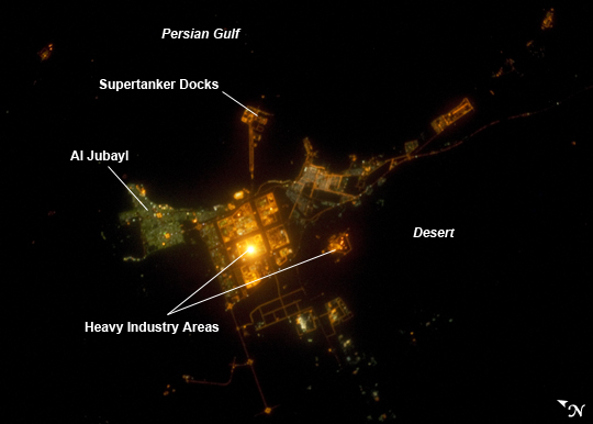 |
| ISS031-E-143143 (19 June 2012) --- Al Jubayl, Saudi Arabia at night is featured in this image photographed by an Expedition 31 crew member on the International Space Station. The city of Al Jubayl (or Jubail) is located on the Saudi Arabian coastline of the Persian Gulf. The city has a history extending back more than 7,000 years, but since 1975 it has been associated with the heavy industries of petrochemical refining and production, fertilizer production and steel works. At night, these industrial areas form a brightly lit region (center) to the south of the residential and commercial center of Al Jubayl (characterized by green-gray lighting). An artificial peninsula extending into the Persian Gulf to the northeast hosts supertanker docks and petroleum storage facilities. The Persian Gulf to the north and northeast is devoid of lights; likewise, the open desert to the south-southeast provides a stark contrast to the well-lit urban and industrial areas. A bright circle of light located within the heavy industrial area (center) cannot be resolved in this photograph, but is likely a concentration of lights associated with ongoing processing or construction activities. The approximate scale of the feature - hundreds of meters in diameter - is consistent with multiple stationary light sources, particularly if the light from those sources is accentuated due to the camera's low light settings. |
| Images: | All Available Images Low-Resolution 118k |
|
| Mission: | ISS031 |
|
| Roll - Frame: | E - 143143 |
|
| Geographical Name: | SAUDI ARABIA |
|
| Features: | JUBAIL AT NIGHT,PETROCHEMICAL REFINERIES,PERSIAN GULF |
|
| Center Lat x Lon: | 27.1N x 49.5E |
|
| Film Exposure: | N=Normal exposure, U=Under exposed, O=Over exposed, F=out of Focus |
|
| Percentage of Cloud Cover-CLDP: | 0 |
|
| Camera:: | N5 |
|
| Camera Tilt: | 23 | LO=Low Oblique, HO=High Oblique, NV=Near Vertical |
| Camera Focal Length: | 200 |
|
| Nadir to Photo Center Direction: | W | The direction from the nadir to the center point, N=North, S=South, E=East, W=West |
| Stereo?: | Y=Yes there is an adjacent picture of the same area, N=No there isn't |
|
| Orbit Number: | |
|
| Date: | 20120619 | YYYYMMDD |
| Time: | 202114 | GMT HHMMSS |
| Nadir Lat: | 27.7N |
Latitude of suborbital point of spacecraft |
| Nadir Lon: | 50.9E |
Longitude of suborbital point of spacecraft |
| Sun Azimuth: | 355 | Clockwise angle in degrees from north to the sun measured at the nadir point |
| Space Craft Altitude: | 211 | nautical miles |
| Sun Elevation: | -39 | Angle in degrees between the horizon and the sun, measured at the nadir point |
| Land Views: | |
|
| Water Views: | |
|
| Atmosphere Views: | |
|
| Man Made Views: | |
|
| City Views: | |
|
Photo is not associated with any sequences | ||
| NASA Home Page |
JSC Home Page |
JSC Digital Image Collection |
Earth Science & Remote Sensing |
|
This service is provided by the International Space Station program and the JSC Earth Science & Remote Sensing Unit, ARES Division, Exploration Integration Science Directorate.

|