
Geographic Region: USA-NEW YORK
Feature: LAKE ONTARIO,LAKE ERIE,LAKE HURON,SUNGLINT,FINGER LAKES,PAN
|
Geographic Region: USA-NEW YORK Feature: LAKE ONTARIO,LAKE ERIE,LAKE HURON,SUNGLINT,FINGER LAKES,PAN |
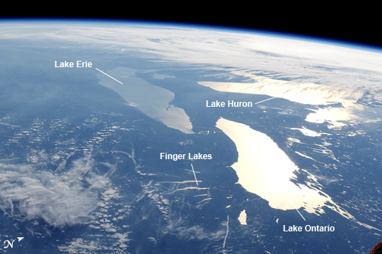 |
| Great Lakes in Sunglint From the vantage point of the International Space Station (ISS), astronauts observe many spectacular phenomena including aurora, noctilucent clouds, airglow, and sunglint on the Earth's water bodies. Sunglint is light reflected off of a water surface towards the observer such that it creates the appearance of a mirror-like surface. If the viewing and lighting conditions are ideal, that mirror-like surface can extend over very large areas, such as the entire surface of Lake Ontario (approximately 18,960 square kilometers). This astronaut photograph was taken while the ISS was located over a point to the southeast of Nova Scotia (approximately 1200 kilometers ground distance from the centerpoint of the image). Lake Ontario, Lake Huron, the Finger Lakes of upstate New York, and numerous other bodies of water appear brilliantly lit by sunglint. To the west, Lake Erie is also highlighted by sunglint, but less light is being reflected back towards the astronaut observer resulting in a duller appearance. Much of central Canada is obscured by extensive cloud cover in the image, whereas a smaller grouping of clouds obscures the Appalachian range and Pennsylvania (image lower left). The blue envelope of the Earth's atmosphere is visible above the curved limb, or horizon line that extends across the upper third of the image. Such panoramic views of the planet are readily taken through ISS viewing ports with handheld digital cameras which allow the astronaut to take advantage of the full range of viewing angles. |
| Images: | All Available Images Low-Resolution 197k |
|
| Mission: | ISS031 |
|
| Roll - Frame: | E - 123071 |
|
| Geographical Name: | USA-NEW YORK |
|
| Features: | LAKE ONTARIO,LAKE ERIE,LAKE HURON,SUNGLINT,FINGER LAKES,PAN |
|
| Center Lat x Lon: | 43.0N x 78.5W |
|
| Film Exposure: | N=Normal exposure, U=Under exposed, O=Over exposed, F=out of Focus |
|
| Percentage of Cloud Cover-CLDP: | 50 |
|
| Camera:: | N2 |
|
| Camera Tilt: | HO | LO=Low Oblique, HO=High Oblique, NV=Near Vertical |
| Camera Focal Length: | 45 |
|
| Nadir to Photo Center Direction: | W | The direction from the nadir to the center point, N=North, S=South, E=East, W=West |
| Stereo?: | Y=Yes there is an adjacent picture of the same area, N=No there isn't |
|
| Orbit Number: | |
|
| Date: | 20120614 | YYYYMMDD |
| Time: | 225234 | GMT HHMMSS |
| Nadir Lat: | 43.9N |
Latitude of suborbital point of spacecraft |
| Nadir Lon: | 64W |
Longitude of suborbital point of spacecraft |
| Sun Azimuth: | 293 | Clockwise angle in degrees from north to the sun measured at the nadir point |
| Space Craft Altitude: | 208 | nautical miles |
| Sun Elevation: | 10 | Angle in degrees between the horizon and the sun, measured at the nadir point |
| Land Views: | RANGE |
|
| Water Views: | LAKE, SUNGLINT |
|
| Atmosphere Views: | |
|
| Man Made Views: | |
|
| City Views: | ERIE, ONTARIO |
|
Photo is not associated with any sequences | ||
| NASA Home Page |
JSC Home Page |
JSC Digital Image Collection |
Earth Science & Remote Sensing |
|
This service is provided by the International Space Station program and the JSC Earth Science & Remote Sensing Unit, ARES Division, Exploration Integration Science Directorate.

|