 Photo #: ISS030-E-99324 Date: Feb. 2012
Geographic Region: UNITED ARAB EMIRATES
Feature: DUBAI AT NIGHT, PALM JUMEIRA COMPLEX, DUBAI MARITIME CITY, BURJ KHALIFA

 Photo #: ISS030-E-99324 Date: Feb. 2012 Photo #: ISS030-E-99324 Date: Feb. 2012Geographic Region: UNITED ARAB EMIRATES Feature: DUBAI AT NIGHT, PALM JUMEIRA COMPLEX, DUBAI MARITIME CITY, BURJ KHALIFA |
 |
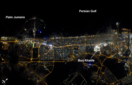
| City Lights of Dubai, United Arab Emirates Note: This caption refers to the image versions labeled "NASA's Earth Observatory web site". The City of Dubai--the largest metropolitan area within the emirate of Dubai--is a favorite subject of astronaut photography largely due to the unique island developments situated directly offshore in the Persian Gulf. These artificial archipelagos have been built such that their full design is only visible from the vantage point of an airplane - or an orbiting spacecraft such as the International Space Station (ISS). Advancements in handheld camera technology and capabilities are also improving the ISS crew's ability to capture detailed night time imagery. The city presents an eye-catching appearance at night that vividly displays the urban development pattern. In this detailed night time image--taken with a long focal length lens and digital camera optimized for fast response and high light sensitivity--several interesting patterns can be observed. The highways and major streets are sharply defined by yellow-orange lighting, while the commercial and residential areas are resolved into a speckle pattern of individual white, blue, and yellow-orange lights. Several large and brilliantly lit areas are large hotel and mall complexes, including the Burj Khalifa Tower; at 828 meters (2717 feet) height it is the world's tallest building. The brilliant lighting of the city contrasts sharply with both the dark Persian Gulf to the northwest, and largely undeveloped and unlit areas to the southeast. Likewise, the clusters of lighting in the Palm Jumeira complex at image top left correspond to the relatively small part of the archipelago that has been developed. Isolated areas of blurred city lights are due to patchy clouds. |
| Images: | All Available Images Low-Resolution 191k |
|
| Mission: | ISS030 |
|
| Roll - Frame: | E - 99324 |
|
| Geographical Name: | UNITED ARAB EMIRATES |
|
| Features: | DUBAI AT NIGHT, PALM JUMEIRA COMPLEX, DUBAI MARITIME CITY, BURJ KHALIFA |
|
| Center Lat x Lon: | 25.1N x 55.1E |
|
| Film Exposure: | N=Normal exposure, U=Under exposed, O=Over exposed, F=out of Focus |
|
| Percentage of Cloud Cover-CLDP: | 10 |
|
| Camera:: | N5 |
|
| Camera Tilt: | 29 | LO=Low Oblique, HO=High Oblique, NV=Near Vertical |
| Camera Focal Length: | 400 |
|
| Nadir to Photo Center Direction: | W | The direction from the nadir to the center point, N=North, S=South, E=East, W=West |
| Stereo?: | Y=Yes there is an adjacent picture of the same area, N=No there isn't |
|
| Orbit Number: | |
|
| Date: | 20120222 | YYYYMMDD |
| Time: | 192400 | GMT HHMMSS |
| Nadir Lat: | 24.3N |
Latitude of suborbital point of spacecraft |
| Nadir Lon: | 56.8E |
Longitude of suborbital point of spacecraft |
| Sun Azimuth: | 311 | Clockwise angle in degrees from north to the sun measured at the nadir point |
| Space Craft Altitude: | 207 | nautical miles |
| Sun Elevation: | -70 | Angle in degrees between the horizon and the sun, measured at the nadir point |
| Land Views: | ISLAND |
|
| Water Views: | GULF |
|
| Atmosphere Views: | |
|
| Man Made Views: | |
|
| City Views: | DUBAI |
|
Photo is not associated with any sequences | ||
| NASA Home Page |
JSC Home Page |
JSC Digital Image Collection |
Earth Science & Remote Sensing |
|
|