
Geographic Region: AUSTRALIA-NSW
Feature: MENINDEE,LAKE MENINDEE,LAKE TANDOU,LAKE WETHERELL
|
Geographic Region: AUSTRALIA-NSW Feature: MENINDEE,LAKE MENINDEE,LAKE TANDOU,LAKE WETHERELL |
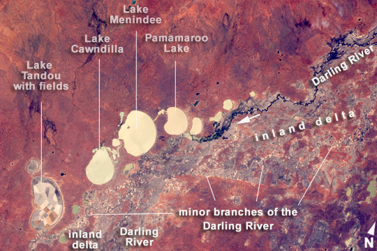 |
| Menindee Lakes, New South Wales, Australia Note: This caption refers to the image versions labeled "NASA's Earth Observatory web site". The Menindee Lakes comprise a system of ephemeral, freshwater lakes fed by the Darling River when it floods. The lakes lie in the far west of New South Wales, Australia, near the town of Menindee. The longest is Lake Tandou (18.6 km north-south dimension), visible at the lower left of this astronaut photograph. The lakes appear to have a small amount of water flooding them. The Darling River itself was flowing, as indicated by the dark water and blackened mud along its course (image right). The Darling River flows southwest in tortuous fashion (top right to lower left in this image). In the flat landscapes of this part of Australia, the river has created several inland deltas in its course to the sea, with characteristic diverging channel patterns, marked by younger sediments, which appear grayer than the surrounding ancient red soils and rocks. One such inland delta appears at image right where minor channels wind across the countryside. The apex of another inland delta appears at image lower left. Some of the Menindee Lakes have been incorporated in an artificially regulated overflow system providing for flood control, water storage for domestic use and livestock, as well as downstream irrigation. The lakes are also important as wetlands supporting a rich diversity of birds. The floor of one lake, Lake Tandou, is also used as prime agricultural land, as can be seen by its patchwork of irrigated fields, and is protected from flooding. |
| Images: | All Available Images Low-Resolution 303k |
|
| Mission: | ISS030 |
|
| Roll - Frame: | E - 9186 |
|
| Geographical Name: | AUSTRALIA-NSW |
|
| Features: | MENINDEE,LAKE MENINDEE,LAKE TANDOU,LAKE WETHERELL |
|
| Center Lat x Lon: | 32.5S x 142.5E |
|
| Film Exposure: | N=Normal exposure, U=Under exposed, O=Over exposed, F=out of Focus |
|
| Percentage of Cloud Cover-CLDP: | 10 |
|
| Camera:: | N2 |
|
| Camera Tilt: | 29 | LO=Low Oblique, HO=High Oblique, NV=Near Vertical |
| Camera Focal Length: | 80 |
|
| Nadir to Photo Center Direction: | E | The direction from the nadir to the center point, N=North, S=South, E=East, W=West |
| Stereo?: | Y=Yes there is an adjacent picture of the same area, N=No there isn't |
|
| Orbit Number: | |
|
| Date: | 20111203 | YYYYMMDD |
| Time: | 015255 | GMT HHMMSS |
| Nadir Lat: | 32S |
Latitude of suborbital point of spacecraft |
| Nadir Lon: | 140.6E |
Longitude of suborbital point of spacecraft |
| Sun Azimuth: | 40 | Clockwise angle in degrees from north to the sun measured at the nadir point |
| Space Craft Altitude: | 216 | nautical miles |
| Sun Elevation: | 78 | Angle in degrees between the horizon and the sun, measured at the nadir point |
| Land Views: | |
|
| Water Views: | CHANNEL, DELTA, FLOODING, LAKE, RIVER, SEA |
|
| Atmosphere Views: | |
|
| Man Made Views: | |
|
| City Views: | |
|
Photo is not associated with any sequences | ||
| NASA Home Page |
JSC Home Page |
JSC Digital Image Collection |
Earth Science & Remote Sensing |
|
This service is provided by the International Space Station program and the JSC Earth Science & Remote Sensing Unit, ARES Division, Exploration Integration Science Directorate.

|