Geographic Region: ARGENTINA
Feature: PERITO MORENO GLACIER, L. ARGENTINO
|
Geographic Region: ARGENTINA Feature: PERITO MORENO GLACIER, L. ARGENTINO |
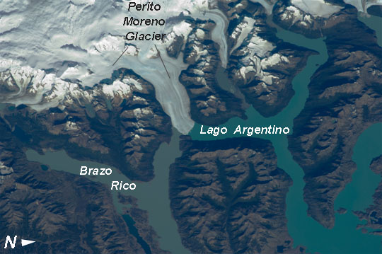 |
| Perito Moreno Glacier, Lake Argentino, Argentina The largest glacier tongue in this image is known as the Perito Moreno Glacier (image center). It descends from the Southern Patagonian Icefield (image top) at great altitudes (>2100 m, 6825 feet) in the southern Andes Mts., down into the water and warmer altitudes of Lake Argentino at ~180 m above sea level. The glacier is 30 km long (image width represents ~60 km on the ground). Perito Moreno is one of the largest glaciers in Patagonia, and is perhaps the most famous for the fact that it periodically cuts off the major southern arm (known as Brazo Rico) of Lake Argentino completely from the rest of the lake. This is because the glacier advances right across the lake until it meets the opposite shoreline. The ice tongue is "grounded" (meaning that it is not floating, as occurs at the termini of glaciers and ice shelves where they enter the sea), thus forming a natural dam which prevents the lake water on either side from circulating, which in turn causes muddier, "milkier" water to concentrate in Brazo Rico. Sub-ice water, now expected to be more active with global warming, flows under the ice, not only carrying the mud into the lake but also helping lubricate the glacier's downhill movement. Because of its effect as a dam, meltwater from the south raises water levels in Brazo Rico by as much as 30 m above the level of the water in L. Argentino. The great pressure of this higher water ultimately causes the ice tongue to rupture catastrophically, in a great natural spectacle. The last rupture took place in March 2012. The process then repeats, on average every 4-5 years, as the glacier starts to grow back towards the opposite shoreline. The repeatability of the rupture has contributed to the event becoming a major tourist attraction in the region. |
| Images: | All Available Images Low-Resolution 99k |
|
| Mission: | ISS030 |
|
| Roll - Frame: | E - 91253 |
|
| Geographical Name: | ARGENTINA |
|
| Features: | PERITO MORENO GLACIER, L. ARGENTINO |
|
| Center Lat x Lon: | 50.4S x 73W |
|
| Film Exposure: | N=Normal exposure, U=Under exposed, O=Over exposed, F=out of Focus |
|
| Percentage of Cloud Cover-CLDP: | 10 |
|
| Camera:: | N2 |
|
| Camera Tilt: | 40 | LO=Low Oblique, HO=High Oblique, NV=Near Vertical |
| Camera Focal Length: | 180 |
|
| Nadir to Photo Center Direction: | W | The direction from the nadir to the center point, N=North, S=South, E=East, W=West |
| Stereo?: | Y=Yes there is an adjacent picture of the same area, N=No there isn't |
|
| Orbit Number: | |
|
| Date: | 20120221 | YYYYMMDD |
| Time: | 131257 | GMT HHMMSS |
| Nadir Lat: | 49.7S |
Latitude of suborbital point of spacecraft |
| Nadir Lon: | 70W |
Longitude of suborbital point of spacecraft |
| Sun Azimuth: | 69 | Clockwise angle in degrees from north to the sun measured at the nadir point |
| Space Craft Altitude: | 219 | nautical miles |
| Sun Elevation: | 30 | Angle in degrees between the horizon and the sun, measured at the nadir point |
| Land Views: | GLACIER |
|
| Water Views: | ICE, LAKE, SEA |
|
| Atmosphere Views: | |
|
| Man Made Views: | DAM |
|
| City Views: | |
|
Photo is not associated with any sequences | ||
| NASA Home Page |
JSC Home Page |
JSC Digital Image Collection |
Earth Science & Remote Sensing |
|
This service is provided by the International Space Station program and the JSC Earth Science & Remote Sensing Unit, ARES Division, Exploration Integration Science Directorate.

|