
Geographic Region: USA-NORTH DAKOTA
Feature: NEW TOWN,LAKE SAKAKAWEA,ICE,SNOW,AGRICULTURAL FIELDS
|
Geographic Region: USA-NORTH DAKOTA Feature: NEW TOWN,LAKE SAKAKAWEA,ICE,SNOW,AGRICULTURAL FIELDS |
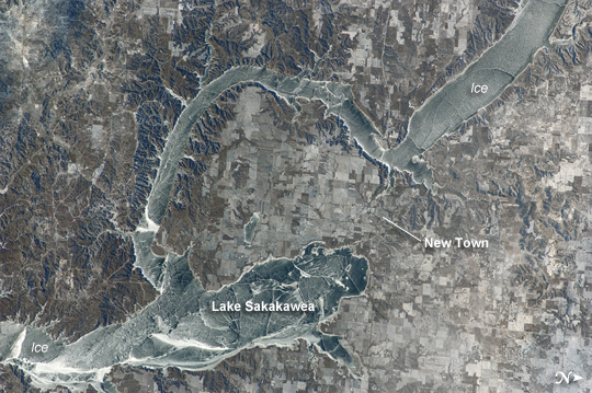 |
| Ice Cover on Lake Sakakawea, North Dakota This striking astronaut photograph, taken from the International Space Station, illustrates the harsh winter conditions frequently experienced in North Dakota. Ice covers the surface of northwestern Lake Sakakawea, a reservoir on the Missouri River in west-central North Dakota. A local weather station near New Town, ND reported an air temperature of approximately -24 degC (-11 degF), with a wind chill of approximately -32 degC (-25 degF) at 10:36 local time - six minutes before the image was taken. In addition to the grey ice on the lake, a dusting of white snow highlights agricultural fields to the north and northeast, as well as fissures and irregularities in the ice surfaces. For a sense of scale, the arms of the lake to either side of New Town are approximately 10 kilometers (6 miles) apart. Lake Sakakawea is named--in the Hidatsa language--for the Shoshone woman generally known as Sacagawea, or "Bird Woman". She accompanied the Lewis and Clark Expedition in 1805 - 1806 as an interpreter and guide. The lake was created following the completion of Garrison Dam (not shown) on the Missouri River in 1954. With a surface area of approximately 148,924 hectares (368,000 acres) and length of 286 kilometers (178 miles), Lake Sakakawea is one of the largest artificial reservoirs in the USA. |
| Images: | All Available Images Low-Resolution 280k |
|
| Mission: | ISS030 |
|
| Roll - Frame: | E - 59433 |
|
| Geographical Name: | USA-NORTH DAKOTA |
|
| Features: | NEW TOWN,LAKE SAKAKAWEA,ICE,SNOW,AGRICULTURAL FIELDS |
|
| Center Lat x Lon: | 47.9N x 102.5W |
|
| Film Exposure: | N=Normal exposure, U=Under exposed, O=Over exposed, F=out of Focus |
|
| Percentage of Cloud Cover-CLDP: | 10 |
|
| Camera:: | N2 |
|
| Camera Tilt: | 24 | LO=Low Oblique, HO=High Oblique, NV=Near Vertical |
| Camera Focal Length: | 180 |
|
| Nadir to Photo Center Direction: | SE | The direction from the nadir to the center point, N=North, S=South, E=East, W=West |
| Stereo?: | Y=Yes there is an adjacent picture of the same area, N=No there isn't |
|
| Orbit Number: | |
|
| Date: | 20120119 | YYYYMMDD |
| Time: | 164210 | GMT HHMMSS |
| Nadir Lat: | 49.3N |
Latitude of suborbital point of spacecraft |
| Nadir Lon: | 103.3W |
Longitude of suborbital point of spacecraft |
| Sun Azimuth: | 146 | Clockwise angle in degrees from north to the sun measured at the nadir point |
| Space Craft Altitude: | 215 | nautical miles |
| Sun Elevation: | 14 | Angle in degrees between the horizon and the sun, measured at the nadir point |
| Land Views: | |
|
| Water Views: | ICE, LAKE, RESERVOIR, RIVER |
|
| Atmosphere Views: | |
|
| Man Made Views: | DAM |
|
| City Views: | |
|
Photo is not associated with any sequences | ||
| NASA Home Page |
JSC Home Page |
JSC Digital Image Collection |
Earth Science & Remote Sensing |
|
This service is provided by the International Space Station program and the JSC Earth Science & Remote Sensing Unit, ARES Division, Exploration Integration Science Directorate.

|