
Geographic Region: USA-GEORGIA
Feature: ATLANTA AT NIGHT,JACKSONVILLE AT NIGHT,BIRMINGHAM AT NIGHT,GULF OF MEXICO
|
Geographic Region: USA-GEORGIA Feature: ATLANTA AT NIGHT,JACKSONVILLE AT NIGHT,BIRMINGHAM AT NIGHT,GULF OF MEXICO |
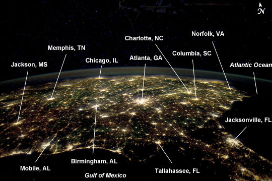 |
| Southeastern USA at Night The southern United States is known for its distinctive cultural and historical identify within the country--this distinctiveness includes music, cuisine, literature, and social customs. The US Census Bureau defines "The South" to include the states of Alabama, Arkansas, Delaware, Florida, Georgia, Kentucky, Louisiana, Maryland, Mississippi, North Carolina, Oklahoma, South Carolina, Tennessee, Texas, Virginia, and West Virginia. This astronaut photograph from the International Space Station highlights the southeastern part of the South at night, including the eastern Gulf of Mexico and lower Atlantic Seaboard states. Following the American Civil War (1861-1865), the southern USA continued to be mostly agrarian until the latter half of the 20th century, when increased migration from other areas of the country (and immigration from outside the USA) led to increased urbanization. The brightly lit metropolitan areas of Atlanta, GA (image center) and Jacksonville, FL (image lower right) appear largest in the image with numerous other urban areas forming an interconnected network of light across the region. A large dark region to the northwest of Jacksonville, FL is the Okefenokee National Wildlife Refuge; likewise the ridges of the Appalachian mountains form dark swaths to the north of Atlanta, GA and west of Charlotte, NC (image center). The faint gold and green line of airglow--caused by ultraviolet radiation exciting the gas molecules in the upper atmosphere--parallels the horizon (or Earth limb). |
| Images: | All Available Images Low-Resolution 213k |
|
| Mission: | ISS030 |
|
| Roll - Frame: | E - 55569 |
|
| Geographical Name: | USA-GEORGIA |
|
| Features: | ATLANTA AT NIGHT,JACKSONVILLE AT NIGHT,BIRMINGHAM AT NIGHT,GULF OF MEXICO |
|
| Center Lat x Lon: | 33.5N x 85W |
|
| Film Exposure: | N=Normal exposure, U=Under exposed, O=Over exposed, F=out of Focus |
|
| Percentage of Cloud Cover-CLDP: | 10 |
|
| Camera:: | N5 |
|
| Camera Tilt: | HO | LO=Low Oblique, HO=High Oblique, NV=Near Vertical |
| Camera Focal Length: | 24 |
|
| Nadir to Photo Center Direction: | N | The direction from the nadir to the center point, N=North, S=South, E=East, W=West |
| Stereo?: | Y=Yes there is an adjacent picture of the same area, N=No there isn't |
|
| Orbit Number: | |
|
| Date: | 20120129 | YYYYMMDD |
| Time: | 053728 | GMT HHMMSS |
| Nadir Lat: | 26.1N |
Latitude of suborbital point of spacecraft |
| Nadir Lon: | 85.5W |
Longitude of suborbital point of spacecraft |
| Sun Azimuth: | 332 | Clockwise angle in degrees from north to the sun measured at the nadir point |
| Space Craft Altitude: | 204 | nautical miles |
| Sun Elevation: | -81 | Angle in degrees between the horizon and the sun, measured at the nadir point |
| Land Views: | |
|
| Water Views: | GULF |
|
| Atmosphere Views: | |
|
| Man Made Views: | |
|
| City Views: | ATLANTA, CHARLOTTE, JACKSONVILLE |
|
Photo is not associated with any sequences | ||
| NASA Home Page |
JSC Home Page |
JSC Digital Image Collection |
Earth Science & Remote Sensing |
|
This service is provided by the International Space Station program and the JSC Earth Science & Remote Sensing Unit, ARES Division, Exploration Integration Science Directorate.

|