Geographic Region: CHAD
Feature: EMI KOUSSI VOLCANO,AORUNGA IMPACT CRATER,YARDANGS
|
Geographic Region: CHAD Feature: EMI KOUSSI VOLCANO,AORUNGA IMPACT CRATER,YARDANGS |
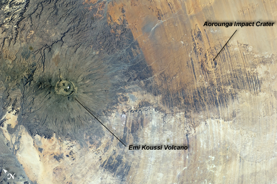 |
| Emi Koussi Volcano and Aorounga Impact Crater, Chad This striking astronaut photograph from the International Space Station features two examples of circular landscape features--labeled as craters--that were produced by very different geological processes. At image left, the broad grey-green shield volcano of Emi Koussi is visible. The volcano is marked by three overlapping calderas formed by eruptions; these form a large oblong depression at the 3,415 meter asl summit of the volcano. A smaller crater sits within the larger caldera depression. While volcanic activity has not been observed, nor is mentioned in the historical record, an active thermal area is located on the southern flank. The circular Aorounga Impact Crater is located approximately 110 km to the southeast of Emi Koussi and has its origin in forces from above rather than eruptions from below. The Aorounga structure is thought to record a meteor impact approximately 345-370 million years ago. The circular feature visible at image upper right may be only one of three impact craters formed by the same event - the other two are buried by sand deposits. The linear features (image lower right) that arc around Emi Koussi and overprint Aorounga and the surrounding bedrock are known as yardangs; these are rock ridges formed by wind erosion. |
| Images: | All Available Images Low-Resolution 257k |
|
| Mission: | ISS030 |
|
| Roll - Frame: | E - 5456 |
|
| Geographical Name: | CHAD |
|
| Features: | EMI KOUSSI VOLCANO,AORUNGA IMPACT CRATER,YARDANGS |
|
| Center Lat x Lon: | 19.5N x 18.5E |
|
| Film Exposure: | N=Normal exposure, U=Under exposed, O=Over exposed, F=out of Focus |
|
| Percentage of Cloud Cover-CLDP: | 0 |
|
| Camera:: | N2 |
|
| Camera Tilt: | 21 | LO=Low Oblique, HO=High Oblique, NV=Near Vertical |
| Camera Focal Length: | 48 |
|
| Nadir to Photo Center Direction: | W | The direction from the nadir to the center point, N=North, S=South, E=East, W=West |
| Stereo?: | Y=Yes there is an adjacent picture of the same area, N=No there isn't |
|
| Orbit Number: | |
|
| Date: | 20111126 | YYYYMMDD |
| Time: | 093403 | GMT HHMMSS |
| Nadir Lat: | 19.6N |
Latitude of suborbital point of spacecraft |
| Nadir Lon: | 19.8E |
Longitude of suborbital point of spacecraft |
| Sun Azimuth: | 161 | Clockwise angle in degrees from north to the sun measured at the nadir point |
| Space Craft Altitude: | 205 | nautical miles |
| Sun Elevation: | 48 | Angle in degrees between the horizon and the sun, measured at the nadir point |
| Land Views: | CALDERA, CRATER, EROSION, VOLCANO |
|
| Water Views: | |
|
| Atmosphere Views: | |
|
| Man Made Views: | |
|
| City Views: | |
|
Photo is not associated with any sequences | ||
| NASA Home Page |
JSC Home Page |
JSC Digital Image Collection |
Earth Science & Remote Sensing |
|
This service is provided by the International Space Station program and the JSC Earth Science & Remote Sensing Unit, ARES Division, Exploration Integration Science Directorate.

|