Geographic Region: SUDAN
Feature: JUBA, WHITE NILE, WETLANDS, ROADS, SMOKE PLUMES
|
Geographic Region: SUDAN Feature: JUBA, WHITE NILE, WETLANDS, ROADS, SMOKE PLUMES |
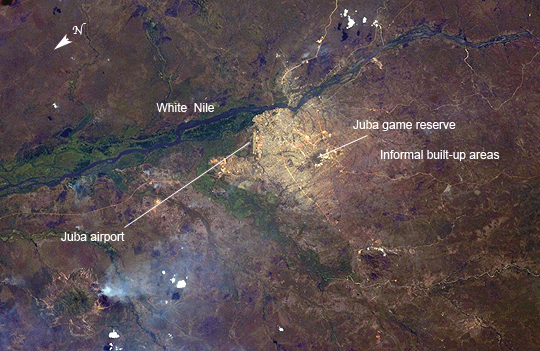 |
| Juba, South Sudan - The World's Newest Capital City Almost one year ago, on July 9, 2011, the Republic of South Sudan became the newest nation in the world, 6 months after its declaration of independence from Sudan. Juba, a port city (image center) on the White Nile, is the capital of the new nation (although the capital will be moved in the future to a more central location) and is one of the fastest growing cities in the world. Juba's population is uncertain, but is estimated to be roughly 350,000-400,000 having doubled in size since 2005, when a peace agreement was signed ending the civil war in Sudan. Both hopeful immigrants and returning residents have created the population surge. The city was a central point for humanitarian aid and both United Nations and non-governmental organization operations during the Sudanese conflicts that culminated in independence; today a significant cadre of foreign aid workers remain in the city. During that conflict period, city infrastructure, including main transportation arteries, suffered heavy damage. The city itself is still surrounded with army camps and squatter settlements (labeled as "informal built-up areas", and appearing as muted gray areas extending outward from the center of the city at image center). The city also hosts the Juba Game Reserve, a protected area of savannah and woodlands that is home to key bird species. Since independence, a variety of countries and international organizations are helping to rebuild Juba's roads, railroads and airport. Unfortunately, South Sudan continues to experience local wars with a variety of armed groups including on-going conflicts with Sudan over oil-rich territories. |
| Images: | All Available Images Low-Resolution 303k |
|
| Mission: | ISS030 |
|
| Roll - Frame: | E - 5199 |
|
| Geographical Name: | SUDAN |
|
| Features: | JUBA, WHITE NILE, WETLANDS, ROADS, SMOKE PLUMES |
|
| Center Lat x Lon: | 4.9N x 31.6E |
|
| Film Exposure: | N=Normal exposure, U=Under exposed, O=Over exposed, F=out of Focus |
|
| Percentage of Cloud Cover-CLDP: | 10 |
|
| Camera:: | N2 |
|
| Camera Tilt: | 24 | LO=Low Oblique, HO=High Oblique, NV=Near Vertical |
| Camera Focal Length: | 145 |
|
| Nadir to Photo Center Direction: | SE | The direction from the nadir to the center point, N=North, S=South, E=East, W=West |
| Stereo?: | Y=Yes there is an adjacent picture of the same area, N=No there isn't |
|
| Orbit Number: | |
|
| Date: | 20111126 | YYYYMMDD |
| Time: | 093838 | GMT HHMMSS |
| Nadir Lat: | 5.7N |
Latitude of suborbital point of spacecraft |
| Nadir Lon: | 30.3E |
Longitude of suborbital point of spacecraft |
| Sun Azimuth: | 176 | Clockwise angle in degrees from north to the sun measured at the nadir point |
| Space Craft Altitude: | 209 | nautical miles |
| Sun Elevation: | 63 | Angle in degrees between the horizon and the sun, measured at the nadir point |
| Land Views: | |
|
| Water Views: | |
|
| Atmosphere Views: | |
|
| Man Made Views: | AIRPORT |
|
| City Views: | SAVANNAH |
|
Photo is not associated with any sequences | ||
| NASA Home Page |
JSC Home Page |
JSC Digital Image Collection |
Earth Science & Remote Sensing |
|
This service is provided by the International Space Station program and the JSC Earth Science & Remote Sensing Unit, ARES Division, Exploration Integration Science Directorate.

|