
Geographic Region: ARGENTINA
Feature: PAN-BLANCA B., GLINT, DUST, ARGENTINE PAMPAS, LAKES, ISS
|
Geographic Region: ARGENTINA Feature: PAN-BLANCA B., GLINT, DUST, ARGENTINE PAMPAS, LAKES, ISS |
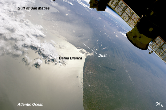 |
| Dust Plume over the Bahia Blanca, South America This panoramic view of eastern Argentina and the Atlantic coastline is centered near Bahia Blanca, which is also highlighted by sun glint - light reflected off the water surface back towards the observer. In this case, the observer was an astronaut on board the International Space Station (ISS). The oblique view looks generally westward (and downwards) from the orbital position of the ISS towards a large plume of dust blowing southeastward from the interior and over the open Atlantic Ocean. The only significant cloud cover was located offshore (image upper left). Northwestern and central Argentina are subject to frequent dust storms where a combination of extensive late Pleistocene loess--fine sediments deposited by wind and typically associated with former continental glaciers--and strong, dry westerly winds descending from the Andes, known locally as the pampero sucio, combine to produce sudden and extensive clouds of the fine soil. The particular dust event illustrated by the image covers much of the province of Rio Negro and the southern parts of the provinces of La Pampa and Buenos Aires as well as the coastal waters between the Gulf of San Matias (image upper left) and Bahia Blanca (image center), located approximately 330 kilometers to the northeast. The area illustrated by the image includes the agriculturally productive southern Pampas plain region where it transitions to the drier, less productive low hills and valleys of northern Patagonia. A docked Russian Progress spacecraft is visible at image upper right. |
| Images: | All Available Images Low-Resolution 169k |
|
| Mission: | ISS030 |
|
| Roll - Frame: | E - 5118 |
|
| Geographical Name: | ARGENTINA |
|
| Features: | PAN-BLANCA B., GLINT, DUST, ARGENTINE PAMPAS, LAKES, ISS |
|
| Center Lat x Lon: | 39S x 62W |
|
| Film Exposure: | N=Normal exposure, U=Under exposed, O=Over exposed, F=out of Focus |
|
| Percentage of Cloud Cover-CLDP: | 25 |
|
| Camera:: | N2 |
|
| Camera Tilt: | HO | LO=Low Oblique, HO=High Oblique, NV=Near Vertical |
| Camera Focal Length: | 28 |
|
| Nadir to Photo Center Direction: | W | The direction from the nadir to the center point, N=North, S=South, E=East, W=West |
| Stereo?: | Y=Yes there is an adjacent picture of the same area, N=No there isn't |
|
| Orbit Number: | |
|
| Date: | 20111122 | YYYYMMDD |
| Time: | 194407 | GMT HHMMSS |
| Nadir Lat: | 39.6S |
Latitude of suborbital point of spacecraft |
| Nadir Lon: | 54.4W |
Longitude of suborbital point of spacecraft |
| Sun Azimuth: | 269 | Clockwise angle in degrees from north to the sun measured at the nadir point |
| Space Craft Altitude: | 224 | nautical miles |
| Sun Elevation: | 32 | Angle in degrees between the horizon and the sun, measured at the nadir point |
| Land Views: | PLAIN |
|
| Water Views: | GULF, OCEAN |
|
| Atmosphere Views: | DUST, PLUME |
|
| Man Made Views: | |
|
| City Views: | BAHIA BLANCA, BUENOS AIRES |
|
Photo is not associated with any sequences | ||
| NASA Home Page |
JSC Home Page |
JSC Digital Image Collection |
Earth Science & Remote Sensing |
|
This service is provided by the International Space Station program and the JSC Earth Science & Remote Sensing Unit, ARES Division, Exploration Integration Science Directorate.

|