
Geographic Region: BALEARIC ISLANDS
Feature: MALLORCA ISLAND,PALMA,CABRERA ISLAND,MEDITERRANEAN SEA
|
Geographic Region: BALEARIC ISLANDS Feature: MALLORCA ISLAND,PALMA,CABRERA ISLAND,MEDITERRANEAN SEA |
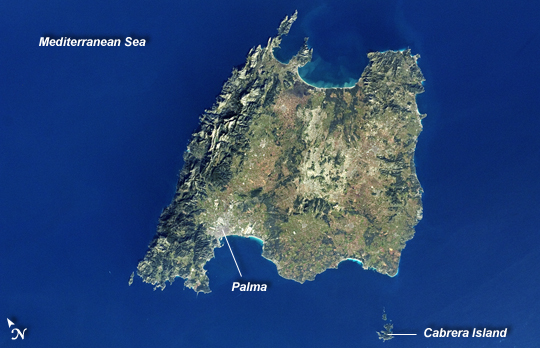 |
| Majorca, Balearic Islands, Spain Note: This caption refers to the image versions labeled "NASA's Earth Observatory web site". The Balearic Islands are an archipelago located to the southwest of Spain in the Mediterranean Sea. Catalan - the native tongue - and Spanish are the official languages. The islands are an autonomous community and province of Spain, located approximately midway between the southeastern coastline of Spain and the northern coastline of Algeria. This astronaut photograph, taken from the International Space Station, highlights the large island of Majorca (approximately 5400 km2; also known as Mallorca in Spanish) on which the capital city of Palma is located (image center). The small island of Cabrera to the southwest of Majorca (image lower right) hosts the Parc Nacional de l'Arxipelag de Cabrera. Like the other Balearic Islands, Majorca is a popular holiday destination for the European community with tourism forming a major part of the island's economy. The island's physiography offers many recreational opportunities - mountainous regions are present along the northwest coastline and eastern third, while much of the central part of the island is flat. Diving is also a popular activity. The central region includes agricultural lands (tan, light brown, and green, image center), forested patches and corridors (dark green, image center), and urban centers (gray). In addition to Majorca, the other major islands of the archipelago include Ibiza, Formentera, and Minorca. |
| Images: | All Available Images Low-Resolution 184k |
|
| Mission: | ISS030 |
|
| Roll - Frame: | E - 30290 |
|
| Geographical Name: | BALEARIC ISLANDS |
|
| Features: | MALLORCA ISLAND,PALMA,CABRERA ISLAND,MEDITERRANEAN SEA |
|
| Center Lat x Lon: | 39.5N x 3.0E |
|
| Film Exposure: | N=Normal exposure, U=Under exposed, O=Over exposed, F=out of Focus |
|
| Percentage of Cloud Cover-CLDP: | 10 |
|
| Camera:: | N2 |
|
| Camera Tilt: | HO | LO=Low Oblique, HO=High Oblique, NV=Near Vertical |
| Camera Focal Length: | 60 |
|
| Nadir to Photo Center Direction: | NE | The direction from the nadir to the center point, N=North, S=South, E=East, W=West |
| Stereo?: | Y=Yes there is an adjacent picture of the same area, N=No there isn't |
|
| Orbit Number: | |
|
| Date: | 20111231 | YYYYMMDD |
| Time: | 122630 | GMT HHMMSS |
| Nadir Lat: | 36.0N |
Latitude of suborbital point of spacecraft |
| Nadir Lon: | 3.1W |
Longitude of suborbital point of spacecraft |
| Sun Azimuth: | 183 | Clockwise angle in degrees from north to the sun measured at the nadir point |
| Space Craft Altitude: | 217 | nautical miles |
| Sun Elevation: | 31 | Angle in degrees between the horizon and the sun, measured at the nadir point |
| Land Views: | ISLAND |
|
| Water Views: | SEA |
|
| Atmosphere Views: | |
|
| Man Made Views: | |
|
| City Views: | |
|
Photo is not associated with any sequences | ||
| NASA Home Page |
JSC Home Page |
JSC Digital Image Collection |
Earth Science & Remote Sensing |
|
This service is provided by the International Space Station program and the JSC Earth Science & Remote Sensing Unit, ARES Division, Exploration Integration Science Directorate.

|