Geographic Region: ALGERIA
Feature: OUARKZIZ IMPACT CRATER, MOUNTAINS, SEDIMENTARY STRATA
|
Geographic Region: ALGERIA Feature: OUARKZIZ IMPACT CRATER, MOUNTAINS, SEDIMENTARY STRATA |
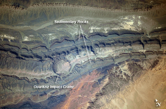 |
| Ouarkziz Impact Crater, Algeria The Ouarkziz Impact Crater is located in northwestern Algeria close to the border with Morocco. The crater was formed by a meteor impact less than 70 million years ago during the late Cretaceous Period of the Mesozoic Era or "Age of Dinosaurs". Originally called Tindouf, the 3.5 kilometer in diameter impact crater (image center) has been heavily eroded since its formation; however its circular morphology is highlighted by exposures of older sedimentary rock layers that form roughly northwest to southeast-trending ridgelines to the north and south. From the vantage point of an astronaut on board the International Space Station, the impact crater is clearly visible with a magnifying camera lens. A geologist interpreting this image to build a working geological history of the region would conclude that the Ouarkziz impact crater is younger than the sedimentary rocks, as the rock layers had to be already present for the meteor to hit them. Likewise, a stream channel is visible cutting across the center of the impact structure (image center), indicating that the channel formed after the impact had occurred. This Principal of Cross-Cutting Relationships, usually attributed to the famous 19th century geologist Charles Lyell, is a basic logic tool used by geologists to build relative sequence and history of events when investigating a region. |
| Images: | All Available Images Low-Resolution 262k |
|
| Mission: | ISS030 |
|
| Roll - Frame: | E - 254011 |
|
| Geographical Name: | ALGERIA |
|
| Features: | OUARKZIZ IMPACT CRATER, MOUNTAINS, SEDIMENTARY STRATA |
|
| Center Lat x Lon: | 29.0N x 7.5W |
|
| Film Exposure: | N=Normal exposure, U=Under exposed, O=Over exposed, F=out of Focus |
|
| Percentage of Cloud Cover-CLDP: | 0 |
|
| Camera:: | N4 |
|
| Camera Tilt: | 21 | LO=Low Oblique, HO=High Oblique, NV=Near Vertical |
| Camera Focal Length: | 400 |
|
| Nadir to Photo Center Direction: | SW | The direction from the nadir to the center point, N=North, S=South, E=East, W=West |
| Stereo?: | Y=Yes there is an adjacent picture of the same area, N=No there isn't |
|
| Orbit Number: | |
|
| Date: | 20120421 | YYYYMMDD |
| Time: | 151348 | GMT HHMMSS |
| Nadir Lat: | 29.8N |
Latitude of suborbital point of spacecraft |
| Nadir Lon: | 6.4W |
Longitude of suborbital point of spacecraft |
| Sun Azimuth: | 255 | Clockwise angle in degrees from north to the sun measured at the nadir point |
| Space Craft Altitude: | 210 | nautical miles |
| Sun Elevation: | 47 | Angle in degrees between the horizon and the sun, measured at the nadir point |
| Land Views: | CRATER |
|
| Water Views: | CHANNEL |
|
| Atmosphere Views: | |
|
| Man Made Views: | |
|
| City Views: | |
|
Photo is not associated with any sequences | ||
| NASA Home Page |
JSC Home Page |
JSC Digital Image Collection |
Earth Science & Remote Sensing |
|
This service is provided by the International Space Station program and the JSC Earth Science & Remote Sensing Unit, ARES Division, Exploration Integration Science Directorate.

|