Geographic Region: RUSSIAN FEDERATION
Feature: KAMCHATKA PENINSULA,ICE FLOES,SHIPUNSKIY CAPE,SNOW
|
Geographic Region: RUSSIAN FEDERATION Feature: KAMCHATKA PENINSULA,ICE FLOES,SHIPUNSKIY CAPE,SNOW |
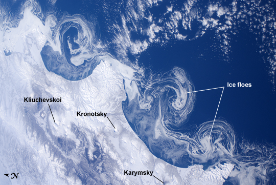 |
| Ice Floes Along the Kamchatka Coastline, Russia The International Space Station astronauts' vantage point from orbit frequently affords them the opportunity to observe processes that are impossible to see on the ground - or in this case the northeastern Pacific Ocean. The winter season blankets the Kamchatka Peninsula of Russia in snow, but significant amounts of sea ice can also form and collect along the coastline. As ice floes grind against each other, they produce smaller floes that can be moved by wind and water currents acting along the coastline. The irregular southeastern coastline of Kamchatka helps to produce large circular eddy currents from the main southwestward-flowing Kamchatka current. Three such eddies are clearly highlighted by surface ice floe patterns at image center. The ice patterns are very difficult (and dangerous) to navigate in an ocean vessel - while the floes may look thin and delicate from the ISS vantage point, even the smaller ice chunks are likely several meters across. White clouds at image top right are distinguished from the sea ice and snow cover in the image by their high brightness and discontinuous nature. The Kamchatka Peninsula also hosts many currently and historically active stratovolcanoes. Kliuchevskoi Volcano, the highest in Kamchatka (summit elevation 4835 meters) and one of the most active, had its most recent confirmed eruption in June of 2011, while Karymsky Volcano to the south likely produced ash plumes days before this image was taken; the snow cover near the volcano to the south and east of the summit is darkened, probably due to a cover of fresh ash, or melted away altogether (image bottom center). In contrast, Kronotsky Volcano - a "textbook" symmetrical cone-shaped stratovolcano - last erupted in 1923. |
| Images: | All Available Images Low-Resolution 265k |
|
| Mission: | ISS030 |
|
| Roll - Frame: | E - 162344 |
|
| Geographical Name: | RUSSIAN FEDERATION |
|
| Features: | KAMCHATKA PENINSULA,ICE FLOES,SHIPUNSKIY CAPE,SNOW |
|
| Center Lat x Lon: | 54.5N x 161.0E |
|
| Film Exposure: | N=Normal exposure, U=Under exposed, O=Over exposed, F=out of Focus |
|
| Percentage of Cloud Cover-CLDP: | 10 |
|
| Camera:: | N2 |
|
| Camera Tilt: | 45 | LO=Low Oblique, HO=High Oblique, NV=Near Vertical |
| Camera Focal Length: | 28 |
|
| Nadir to Photo Center Direction: | N | The direction from the nadir to the center point, N=North, S=South, E=East, W=West |
| Stereo?: | Y=Yes there is an adjacent picture of the same area, N=No there isn't |
|
| Orbit Number: | |
|
| Date: | 20120315 | YYYYMMDD |
| Time: | 232752 | GMT HHMMSS |
| Nadir Lat: | 51.4N |
Latitude of suborbital point of spacecraft |
| Nadir Lon: | 162.5E |
Longitude of suborbital point of spacecraft |
| Sun Azimuth: | 147 | Clockwise angle in degrees from north to the sun measured at the nadir point |
| Space Craft Altitude: | 204 | nautical miles |
| Sun Elevation: | 32 | Angle in degrees between the horizon and the sun, measured at the nadir point |
| Land Views: | PENINSULA, VOLCANO |
|
| Water Views: | EDDY, ICE, OCEAN, SEA, SEA ICE |
|
| Atmosphere Views: | |
|
| Man Made Views: | |
|
| City Views: | |
|
Photo is not associated with any sequences | ||
| NASA Home Page |
JSC Home Page |
JSC Digital Image Collection |
Earth Science & Remote Sensing |
|
This service is provided by the International Space Station program and the JSC Earth Science & Remote Sensing Unit, ARES Division, Exploration Integration Science Directorate.

|