Geographic Region: NORTHERN MARIANA IS.
Feature: PAGAN ISLAND,NORTH PAGAN VOLCANO PLUME,SHOMUSHON
|
Geographic Region: NORTHERN MARIANA IS. Feature: PAGAN ISLAND,NORTH PAGAN VOLCANO PLUME,SHOMUSHON |
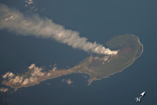 |
| Pagan Island, Northern Marianas A steam plume flows south from the peak of Pagan Island's northernmost volcano in this astronaut photograph. Pagan is part of the Commonwealth of the Northern Marianas, an island chain of volcanoes that form the margin between the Pacific Ocean (to the east) and the Philippine Sea (to the west). Pagan is made up of two stratovolcanoes separated by an isthmus, and is one of the more volcanically active islands. The last eruption was in 2010, but the island was completely evacuated in 1981 when a large eruption forced the small Micronesian community to flee. The islands themselves mark the tectonic boundary where the old, cold Pacific plate is subducted beneath the younger, less dense Philippine Sea crust at the Marianas trench. The subduction results in substantial volcanic activity on the upper plate, forming the island arc of the Marianas. Considered to be one of the type examples for an oceanic subduction zone, the Marianas Trench includes the deepest spot in the Earth's oceans (more than 10,000m). The foreshortened appearance of the island is due to the viewing angle and distance from the International Space Station (ISS). The ISS was located over the Pacific Ocean approximately 480 kilometers to the southeast of Pagan Island when the image was taken. |
| Images: | All Available Images Low-Resolution 123k |
|
| Mission: | ISS030 |
|
| Roll - Frame: | E - 122047 |
|
| Geographical Name: | NORTHERN MARIANA IS. |
|
| Features: | PAGAN ISLAND,NORTH PAGAN VOLCANO PLUME,SHOMUSHON |
|
| Center Lat x Lon: | 18.1N x 145.7E |
|
| Film Exposure: | N=Normal exposure, U=Under exposed, O=Over exposed, F=out of Focus |
|
| Percentage of Cloud Cover-CLDP: | 10 |
|
| Camera:: | N4 |
|
| Camera Tilt: | 52 | LO=Low Oblique, HO=High Oblique, NV=Near Vertical |
| Camera Focal Length: | 1200 |
|
| Nadir to Photo Center Direction: | W | The direction from the nadir to the center point, N=North, S=South, E=East, W=West |
| Stereo?: | Y=Yes there is an adjacent picture of the same area, N=No there isn't |
|
| Orbit Number: | |
|
| Date: | 20120306 | YYYYMMDD |
| Time: | 221402 | GMT HHMMSS |
| Nadir Lat: | 16.8N |
Latitude of suborbital point of spacecraft |
| Nadir Lon: | 150.0E |
Longitude of suborbital point of spacecraft |
| Sun Azimuth: | 105 | Clockwise angle in degrees from north to the sun measured at the nadir point |
| Space Craft Altitude: | 212 | nautical miles |
| Sun Elevation: | 28 | Angle in degrees between the horizon and the sun, measured at the nadir point |
| Land Views: | ISLAND, VOLCANO |
|
| Water Views: | OCEAN, SEA |
|
| Atmosphere Views: | PLUME |
|
| Man Made Views: | |
|
| City Views: | |
|
Photo is not associated with any sequences | ||
| NASA Home Page |
JSC Home Page |
JSC Digital Image Collection |
Earth Science & Remote Sensing |
|
This service is provided by the International Space Station program and the JSC Earth Science & Remote Sensing Unit, ARES Division, Exploration Integration Science Directorate.

|