Geographic Region: ANTARCTICA
Feature: DECEPTION ISLAND,HOSEASON ISLAND,BRABANT ISLAND,ANTARCTIC PENINSULA
|
Geographic Region: ANTARCTICA Feature: DECEPTION ISLAND,HOSEASON ISLAND,BRABANT ISLAND,ANTARCTIC PENINSULA |
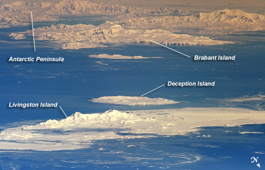 |
| International Space Station View of South Shetland Islands and Antarctic Peninsula Note: This caption refers to the image versions labeled "NASA's Earth Observatory web site". The inclined equatorial orbit of the International Space Station (ISS) limits nadir Earth views--looking "straight down" at the surface from the spacecraft--to latitudes between approximately 52 North and 52 South. When viewing conditions are ideal, the crew can obtain detailed oblique imagery--looking outwards at an angle from the ISS--of regions at higher latitudes such as Greenland or, in this image, Antarctica. While the bulk of the continent of Antarctica is currently situated over the South Pole, the narrow Antarctic Peninsula extends like a finger towards the southern tip of South America. The northernmost part of the Peninsula is known as Graham Land, a small portion of which (located at approximately 64 South latitude) can be seen at image top left in this astronaut photograph. Two of the South Shetland Islands that lay off the coast of Graham Land to the north-northwest, Livingston Island and Deception Island, are visible in the image. While both islands have a volcanic origin, active volcanism at Deception Island has been recorded since 1800; the last verified eruptive activity occurred in 1970. Closer to the coastline of Graham Land, Brabant Island (not considered to be part of the South Shetlands) also includes numerous outcrops of volcanic rock attesting to the complex tectonic history of the region. The ISS was located over the South Atlantic Ocean, approximately 1800 kilometers to the northeast in terms of its ground track, when this image was taken. This long viewing distance, combined with the highly oblique viewing angle, accentuates shadowing of the ground surface and provides a sense of the topography similar to the view one gets from an airplane. It also causes foreshortening of features visible in the image, making them appear closer to each other than they actually are - for example, the actual distance between Livingston and Deception Islands is approximately 20 kilometers. |
| Images: | All Available Images Low-Resolution 210k |
|
| Mission: | ISS029 |
|
| Roll - Frame: | E - 41836 |
|
| Geographical Name: | ANTARCTICA |
|
| Features: | DECEPTION ISLAND,HOSEASON ISLAND,BRABANT ISLAND,ANTARCTIC PENINSULA |
|
| Center Lat x Lon: | 63.3S x 61.1W |
|
| Film Exposure: | N=Normal exposure, U=Under exposed, O=Over exposed, F=out of Focus |
|
| Percentage of Cloud Cover-CLDP: | 10 |
|
| Camera:: | N3 |
|
| Camera Tilt: | HO | LO=Low Oblique, HO=High Oblique, NV=Near Vertical |
| Camera Focal Length: | 1200 |
|
| Nadir to Photo Center Direction: | SW | The direction from the nadir to the center point, N=North, S=South, E=East, W=West |
| Stereo?: | Y=Yes there is an adjacent picture of the same area, N=No there isn't |
|
| Orbit Number: | |
|
| Date: | 20111004 | YYYYMMDD |
| Time: | 163136 | GMT HHMMSS |
| Nadir Lat: | 49.2S |
Latitude of suborbital point of spacecraft |
| Nadir Lon: | 45.6W |
Longitude of suborbital point of spacecraft |
| Sun Azimuth: | 326 | Clockwise angle in degrees from north to the sun measured at the nadir point |
| Space Craft Altitude: | 206 | nautical miles |
| Sun Elevation: | 41 | Angle in degrees between the horizon and the sun, measured at the nadir point |
| Land Views: | COAST, ISLAND, PENINSULA |
|
| Water Views: | OCEAN |
|
| Atmosphere Views: | |
|
| Man Made Views: | |
|
| City Views: | |
|
Photo is not associated with any sequences | ||
| NASA Home Page |
JSC Home Page |
JSC Digital Image Collection |
Earth Science & Remote Sensing |
|
This service is provided by the International Space Station program and the JSC Earth Science & Remote Sensing Unit, ARES Division, Exploration Integration Science Directorate.

|