Geographic Region: RUSSIAN FEDERATION
Feature: SELENGINSK,LAKE BAIKAL,SELENGE RIVER DELTA,AGRICULTURAL FIELDS
|
Geographic Region: RUSSIAN FEDERATION Feature: SELENGINSK,LAKE BAIKAL,SELENGE RIVER DELTA,AGRICULTURAL FIELDS |
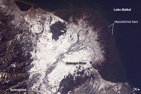 |
| Snowfall on the Selenga River Delta, Russian Federation This astronaut photograph from the International Space Station illustrates the Selenga River Delta built out into Lake Baikal in Russia. The Selenga River delta (image center) is lobate in form, with an intricate network of distributary channels and levees surrounded by marshlands building out into Lake Baikal. This suggests that development of the delta is governed by the sediment load carried by the river, and any modifications of form due to lake tides or waves are relatively minor. Further out, dark brown depositional bars are visible forming a rough arc marking the edge of the delta. Snow cover on the river floodplain highlights numerous secondary channels, as well as channels previously occupied by the river but now abandoned. The regular outlines of agricultural fields to the southwest and northeast of the river are also highlighted by the snow cover. Lake Baikal is a World Heritage Site. The Selenga River is the major contributor of water to Lake Baikal; it occupies approximately 82% of the watershed area for the lake. The wetlands of the Selenga River delta are designated as a RAMSAR site and provide valuable habitat for more than 170 species of birds, including many migrating species. Like Baikal, the Selenga Delta is home to unique ecosystems, including more than 70 rare or endangered species of plants and animals. Waters of the Selenga River serve many (and differing) uses in both Mongolia and Russia, including support of agriculture, provision of drinking water, light industry, mining, recreation, and tourism. These uses also contribute to degradation of the river water quality, downstream availability of water, and ecological impacts. For example, a pulp and paper plant in the city of Selenginsk (image lower left) has been tied to high levels of pollution in the river. International efforts to integrate management of the Selenga River basin for both ecological and economic sustainability are ongoing. |
| Images: | All Available Images Low-Resolution 218k |
|
| Mission: | ISS029 |
|
| Roll - Frame: | E - 37915 |
|
| Geographical Name: | RUSSIAN FEDERATION |
|
| Features: | SELENGINSK,LAKE BAIKAL,SELENGE RIVER DELTA,AGRICULTURAL FIELDS |
|
| Center Lat x Lon: | 52.2N x 106.6E |
|
| Film Exposure: | N=Normal exposure, U=Under exposed, O=Over exposed, F=out of Focus |
|
| Percentage of Cloud Cover-CLDP: | 10 |
|
| Camera:: | N2 |
|
| Camera Tilt: | 38 | LO=Low Oblique, HO=High Oblique, NV=Near Vertical |
| Camera Focal Length: | 125 |
|
| Nadir to Photo Center Direction: | E | The direction from the nadir to the center point, N=North, S=South, E=East, W=West |
| Stereo?: | Y=Yes there is an adjacent picture of the same area, N=No there isn't |
|
| Orbit Number: | |
|
| Date: | 20111103 | YYYYMMDD |
| Time: | 073442 | GMT HHMMSS |
| Nadir Lat: | 51.3N |
Latitude of suborbital point of spacecraft |
| Nadir Lon: | 104.1E |
Longitude of suborbital point of spacecraft |
| Sun Azimuth: | 222 | Clockwise angle in degrees from north to the sun measured at the nadir point |
| Space Craft Altitude: | 203 | nautical miles |
| Sun Elevation: | 14 | Angle in degrees between the horizon and the sun, measured at the nadir point |
| Land Views: | BASIN |
|
| Water Views: | DELTA, LAKE, RIVER, SEDIMENT |
|
| Atmosphere Views: | |
|
| Man Made Views: | AGRICULTURE, MINING, POLLUTION |
|
| City Views: | |
|
Photo is not associated with any sequences | ||
| NASA Home Page |
JSC Home Page |
JSC Digital Image Collection |
Earth Science & Remote Sensing |
|
This service is provided by the International Space Station program and the JSC Earth Science & Remote Sensing Unit, ARES Division, Exploration Integration Science Directorate.

|