
Geographic Region: EGYPT
Feature: EGYPT-ISRAEL BORDER, HURAYDIN R., AGR.
|
Geographic Region: EGYPT Feature: EGYPT-ISRAEL BORDER, HURAYDIN R., AGR. |
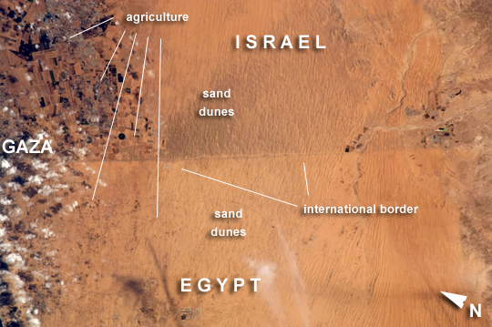 |
| Egypt-Israel Borderlands, Northern Sinai Peninsula and Northern Negev Desert Note: This caption refers to the image versions labeled "NASA's Earth Observatory web site". A clearly visible line marks about 50 kilometers of the international border between Egypt and Israel in this astronaut photograph. The area shown lies between 10 to 60 kilometers (from left to right) from the Mediterranean Sea, which is beyond this image to the northwest. This image from the International Space Station shows the characteristic sand dune morphology of the region and the poor soils which mark the southern limit of agriculture. The different colors of the land surface are the result of trampling by humans and their livestock. Trampling disturbs the dark-colored soil crusts on the Egyptian side of the border, allowing lighter-colored dune sand beneath the crusts to be exposed by winds. A road also follows the border, making the demarcation more prominent. A patch of the Gaza Strip appears under scattered clouds at extreme image left. In the arid to semiarid climate of the region, the natural vegetation is mostly sparse shrubs. Irrigated commercial agriculture in Israel appears as a series of large angular patterns and circular center pivot fields, with darker greens indicating growing crops (image left). Smaller plots appear on the Egyptian side of the border at image lower left. |
| Images: | All Available Images Low-Resolution 242k |
|
| Mission: | ISS029 |
|
| Roll - Frame: | E - 37471 |
|
| Geographical Name: | EGYPT |
|
| Features: | EGYPT-ISRAEL BORDER, HURAYDIN R., AGR. |
|
| Center Lat x Lon: | 31.0N x 34.3E |
|
| Film Exposure: | N=Normal exposure, U=Under exposed, O=Over exposed, F=out of Focus |
|
| Percentage of Cloud Cover-CLDP: | 10 |
|
| Camera:: | N2 |
|
| Camera Tilt: | 27 | LO=Low Oblique, HO=High Oblique, NV=Near Vertical |
| Camera Focal Length: | 200 |
|
| Nadir to Photo Center Direction: | E | The direction from the nadir to the center point, N=North, S=South, E=East, W=West |
| Stereo?: | Y=Yes there is an adjacent picture of the same area, N=No there isn't |
|
| Orbit Number: | |
|
| Date: | 20111103 | YYYYMMDD |
| Time: | 085618 | GMT HHMMSS |
| Nadir Lat: | 31.6N |
Latitude of suborbital point of spacecraft |
| Nadir Lon: | 32.7E |
Longitude of suborbital point of spacecraft |
| Sun Azimuth: | 168 | Clockwise angle in degrees from north to the sun measured at the nadir point |
| Space Craft Altitude: | 201 | nautical miles |
| Sun Elevation: | 43 | Angle in degrees between the horizon and the sun, measured at the nadir point |
| Land Views: | COAST, DESERT, PENINSULA |
|
| Water Views: | SEA |
|
| Atmosphere Views: | |
|
| Man Made Views: | AGRICULTURE, HIGHWAY |
|
| City Views: | GAZA |
|
Photo is not associated with any sequences | ||
| NASA Home Page |
JSC Home Page |
JSC Digital Image Collection |
Earth Science & Remote Sensing |
|
This service is provided by the International Space Station program and the JSC Earth Science & Remote Sensing Unit, ARES Division, Exploration Integration Science Directorate.

|