 Photo #: ISS029-E-34092 Date: Oct. 2011
Geographic Region: PACIFIC OCEAN
Feature: PROGRESS SPACECRAFT REENTRY,AIRGLOW,NIGHT,SUNRISE
|
Photo #: ISS029-E-34092 Date: Oct. 2011 Geographic Region: PACIFIC OCEAN Feature: PROGRESS SPACECRAFT REENTRY,AIRGLOW,NIGHT,SUNRISE |
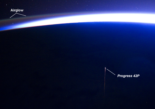 |
| Re-entry of Progress Spacecraft 42P Have you ever wondered how the astronauts and cosmonauts on board the International Space Station (ISS) take out their trash? Several times a year, robotic spacecraft carrying a variety of items including food, water, fuel, oxygen, medical supplies, replacement parts, and research materials are launched from Earth to dock with the ISS. These spacecraft are built and launched by the ISS international partners Russia, Japan, and the European Space Agency. After its cargo has been transferred to the ISS, the spacecraft is refilled with refuse, and then undocked and de-orbited--essentially using the Earth's atmosphere as an incinerator for both the spent spacecraft and the refuse. This unusual astronaut photograph highlights the reentry plasma trail (image center) of one such spacecraft, the ISS Progress 42P (Russian designation M-10M) supply vehicle. The Progress spacecraft is based on the Soyuz design, and can fly autonomously or under remote control from the ISS. Progress 42P docked at the ISS on April 29 2011, and was undocked and de-orbited approximately 183 days later on October 29 2011. The ISS was located over the southern Pacific Ocean when this image was taken. Light from the rising sun illuminates the curvature of the Earth limb (horizon line) at image top, but does not completely overwhelm the airglow visible at image top left. Airglow is caused by light emitted at specific wavelengths by atoms and molecules excited by ultraviolet radiation in the upper atmosphere. |
| Images: | All Available Images Low-Resolution 152k |
|
| Mission: | ISS029 |
|
| Roll - Frame: | E - 34092 |
|
| Geographical Name: | PACIFIC OCEAN |
|
| Features: | PROGRESS SPACECRAFT REENTRY,AIRGLOW,NIGHT,SUNRISE |
|
| Center Lat x Lon: | N x E |
|
| Film Exposure: | N=Normal exposure, U=Under exposed, O=Over exposed, F=out of Focus |
|
| Percentage of Cloud Cover-CLDP: | 0 |
|
| Camera:: | N5 |
|
| Camera Tilt: | LO | LO=Low Oblique, HO=High Oblique, NV=Near Vertical |
| Camera Focal Length: | 38 |
|
| Nadir to Photo Center Direction: | The direction from the nadir to the center point, N=North, S=South, E=East, W=West |
|
| Stereo?: | Y=Yes there is an adjacent picture of the same area, N=No there isn't |
|
| Orbit Number: | |
|
| Date: | 20111029 | YYYYMMDD |
| Time: | 125240 | GMT HHMMSS |
| Nadir Lat: | 40.5S |
Latitude of suborbital point of spacecraft |
| Nadir Lon: | 164W |
Longitude of suborbital point of spacecraft |
| Sun Azimuth: | 143 | Clockwise angle in degrees from north to the sun measured at the nadir point |
| Space Craft Altitude: | 217 | nautical miles |
| Sun Elevation: | -28 | Angle in degrees between the horizon and the sun, measured at the nadir point |
| Land Views: | |
|
| Water Views: | OCEAN |
|
| Atmosphere Views: | |
|
| Man Made Views: | |
|
| City Views: | |
|
Photo is not associated with any sequences | ||
| NASA Home Page |
JSC Home Page |
JSC Digital Image Collection |
Earth Science & Remote Sensing |
|
This service is provided by the International Space Station program and the JSC Earth Science & Remote Sensing Unit, ARES Division, Exploration Integration Science Directorate.

|