 Photo #: ISS029-E-31270 Date: Oct. 2011
Geographic Region: INDIA
Feature: CREPUSCULAR RAYS,CLOUD,HAZE
|
Photo #: ISS029-E-31270 Date: Oct. 2011 Geographic Region: INDIA Feature: CREPUSCULAR RAYS,CLOUD,HAZE |
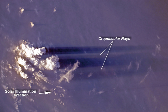 |
| Crepuscular Rays, India Note: This caption refers to the image versions labeled "NASA's Earth Observatory web site". The sight of shafts of light, beaming down from the heavens through a layer of clouds, has provided many an artist, scientist, and philosopher with inspiration throughout the centuries. Atmospheric scientists refer to this phenomenon as "crepuscular rays", referring to the typical observation times of either sunrise or sunset. Shadowed areas bounding the rays are formed by obstructions in the solar (or lunar) illumination pathway such as clouds or mountain tops; however this alone is not sufficient to create the phenomenon. The light must also be scattered - by airborne dust, aerosols, water droplets, or molecules of the air itself--to provide the visible contrast between the shadowed and illuminated parts of the sky. When observed from the ground, crepuscular rays appear to radiate outwards from the source of illumination due to the effects of distance and perspective; however the rays are actually parallel. This astronaut photograph from the International Space Station provides an unusual viewing perspective from above the rays. The sun was setting to the west (image left) on the Indian subcontinent at the time the image was taken, and cumulonimbus cloud towers provide the shadowing obstructions. The rays are being projected onto a layer of haze below the cloud towers. The image clearly illustrates the true parallel nature of the crepuscular rays. |
| Images: | All Available Images Low-Resolution 149k |
|
| Mission: | ISS029 |
|
| Roll - Frame: | E - 31270 |
|
| Geographical Name: | INDIA |
|
| Features: | CREPUSCULAR RAYS,CLOUD,HAZE |
|
| Center Lat x Lon: | N x E |
|
| Film Exposure: | N=Normal exposure, U=Under exposed, O=Over exposed, F=out of Focus |
|
| Percentage of Cloud Cover-CLDP: | 25 |
|
| Camera:: | N2 |
|
| Camera Tilt: | LO | LO=Low Oblique, HO=High Oblique, NV=Near Vertical |
| Camera Focal Length: | 110 |
|
| Nadir to Photo Center Direction: | The direction from the nadir to the center point, N=North, S=South, E=East, W=West |
|
| Stereo?: | Y=Yes there is an adjacent picture of the same area, N=No there isn't |
|
| Orbit Number: | 2016 |
|
| Date: | 20111018 | YYYYMMDD |
| Time: | 113253 | GMT HHMMSS |
| Nadir Lat: | 24.0N |
Latitude of suborbital point of spacecraft |
| Nadir Lon: | 80.8E |
Longitude of suborbital point of spacecraft |
| Sun Azimuth: | 256 | Clockwise angle in degrees from north to the sun measured at the nadir point |
| Space Craft Altitude: | 202 | nautical miles |
| Sun Elevation: | 7 | Angle in degrees between the horizon and the sun, measured at the nadir point |
| Land Views: | MOUNTAIN |
|
| Water Views: | |
|
| Atmosphere Views: | DUST, HAZE |
|
| Man Made Views: | |
|
| City Views: | |
|
Photo is not associated with any sequences | ||
| NASA Home Page |
JSC Home Page |
JSC Digital Image Collection |
Earth Science & Remote Sensing |
|
This service is provided by the International Space Station program and the JSC Earth Science & Remote Sensing Unit, ARES Division, Exploration Integration Science Directorate.

|