
Geographic Region: USA-CONNECTICUT
Feature: PAN- LONG ISLAND, BLOCK I., GLINT, MARTHA'S VINEYARD, CAPE COD, BOSTON
|
Geographic Region: USA-CONNECTICUT Feature: PAN- LONG ISLAND, BLOCK I., GLINT, MARTHA'S VINEYARD, CAPE COD, BOSTON |
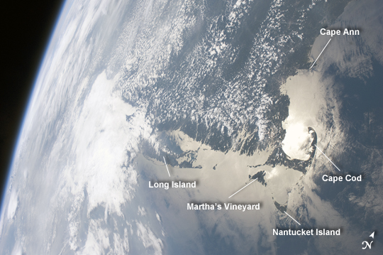 |
| Massachusetts Coastline in Sunglint Note: This caption refers to the image versions labeled "NASA's Earth Observatory web site". The Crew Earth Observations team at NASA Johnson Space Center sends specific ground targets for photography up to the International Space Station (ISS) crew on a daily basis, but sometimes the crew takes imagery on their own of striking displays visible from orbit. One such display, often visible to the ISS crew due to their ability to look outwards at angles between 0 and 90 degrees, is sunglint on the waters of Earth. Sunglint is caused by sunlight reflecting off of a water surface--much as light reflects from a mirror--directly towards the observer. Roughness variations of the water surface scatter the light, blurring the reflection and producing the typical silvery sheen of the sunglint area. The point of maximum sunglint is centered within Cape Cod Bay, the body of water partially enclosed by the "hook" of Cape Cod (image right). Cape Cod was formally designated a National Seashore in 1966. Sunglint off the water provides sharp contrast with the coastline and the nearby islands of Martha's Vineyard and Nantucket (image lower right), both popular destinations for tourists and summer residents. To the north, rocky Cape Ann extends out into the Atlantic Ocean; the border with New Hampshire is located approximately 30 kilometers up the coast. Further to the west, the eastern half of Long Island, New York is visible emerging from extensive cloud cover over the mid-Atlantic and Midwestern States. Persistent storm tracks had been contributing to record flooding along rivers in the Midwest at the time this image was taken in late June 2011. Thin blue layers of the atmosphere, contrasted against the darkness of space, are visible extending along the Earth's curvature at image left. |
| Images: | All Available Images Low-Resolution 204k |
|
| Mission: | ISS028 |
|
| Roll - Frame: | E - 9979 |
|
| Geographical Name: | USA-CONNECTICUT |
|
| Features: | PAN- LONG ISLAND, BLOCK I., GLINT, MARTHA'S VINEYARD, CAPE COD, BOSTON |
|
| Center Lat x Lon: | 41.5N x 72.5W |
|
| Film Exposure: | N=Normal exposure, U=Under exposed, O=Over exposed, F=out of Focus |
|
| Percentage of Cloud Cover-CLDP: | 75 |
|
| Camera:: | N2 |
|
| Camera Tilt: | HO | LO=Low Oblique, HO=High Oblique, NV=Near Vertical |
| Camera Focal Length: | 28 |
|
| Nadir to Photo Center Direction: | W | The direction from the nadir to the center point, N=North, S=South, E=East, W=West |
| Stereo?: | Y=Yes there is an adjacent picture of the same area, N=No there isn't |
|
| Orbit Number: | 257 |
|
| Date: | 20110627 | YYYYMMDD |
| Time: | 201238 | GMT HHMMSS |
| Nadir Lat: | 42.0N |
Latitude of suborbital point of spacecraft |
| Nadir Lon: | 66.7W |
Longitude of suborbital point of spacecraft |
| Sun Azimuth: | 266 | Clockwise angle in degrees from north to the sun measured at the nadir point |
| Space Craft Altitude: | 205 | nautical miles |
| Sun Elevation: | 40 | Angle in degrees between the horizon and the sun, measured at the nadir point |
| Land Views: | CAPE, COAST, ISLAND |
|
| Water Views: | BAY, OCEAN, SUNGLINT |
|
| Atmosphere Views: | |
|
| Man Made Views: | |
|
| City Views: | |
|
Photo is not associated with any sequences | ||
| NASA Home Page |
JSC Home Page |
JSC Digital Image Collection |
Earth Science & Remote Sensing |
|
This service is provided by the International Space Station program and the JSC Earth Science & Remote Sensing Unit, ARES Division, Exploration Integration Science Directorate.

|