
Geographic Region: ITALY
Feature: PAN-SOUTHERN ITALIAN PENINSULA-SICILY AT NIGHT, ISS
|
Geographic Region: ITALY Feature: PAN-SOUTHERN ITALIAN PENINSULA-SICILY AT NIGHT, ISS |
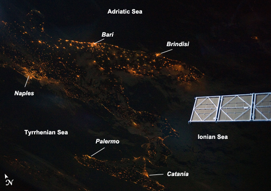 |
| Southern Italian Peninsula at Night Note: This caption refers to the image versions labeled "NASA's Earth Observatory web site". The Earth's surface at night is covered with a delicate tracery of lights, particularly in regions - such as Europe - that have a long history of urban development. Large urban areas are recognizable from orbit due to extensive electric lighting and distinct street patterns; with smaller urban areas spread across the land surface and coastlines, the outlines of continental landmasses are easily discernable at night. This astronaut photograph highlights the night time appearance of the southern Italian Peninsula; the toe and heel of Italy's "boot" are clearly defined by the lights of large cities such as Naples, Bari, and Brindisi as well as numerous smaller urban areas. The bordering Adriatic, Tyrrhenian, and Ionian Seas appear as dark regions to the east, west, and south of the boot. The city lights of Palermo and Catania on the island of Sicily are visible at image bottom center. The International Space Station (ISS) was located over an area of Romania close to the capital city of Bucharest - approximately 945 kilometers to the northeast--at the time this image was taken. Part of a docked Russian spacecraft solar panel array is visible in the foreground at image right. The distance between the image subject area and the position of the astronaut-photographer, as well as the viewing angle looking outwards from the ISS, contributes to the foreshortened appearance of the Italian Peninsula and Sicily in the image. |
| Images: | All Available Images Low-Resolution 201k |
|
| Mission: | ISS028 |
|
| Roll - Frame: | E - 8604 |
|
| Geographical Name: | ITALY |
|
| Features: | PAN-SOUTHERN ITALIAN PENINSULA-SICILY AT NIGHT, ISS |
|
| Center Lat x Lon: | 40.0N x 16.5E |
|
| Film Exposure: | N=Normal exposure, U=Under exposed, O=Over exposed, F=out of Focus |
|
| Percentage of Cloud Cover-CLDP: | 50 |
|
| Camera:: | N5 |
|
| Camera Tilt: | HO | LO=Low Oblique, HO=High Oblique, NV=Near Vertical |
| Camera Focal Length: | 35 |
|
| Nadir to Photo Center Direction: | SW | The direction from the nadir to the center point, N=North, S=South, E=East, W=West |
| Stereo?: | Y=Yes there is an adjacent picture of the same area, N=No there isn't |
|
| Orbit Number: | 4007 |
|
| Date: | 20110611 | YYYYMMDD |
| Time: | 205310 | GMT HHMMSS |
| Nadir Lat: | 44.4N |
Latitude of suborbital point of spacecraft |
| Nadir Lon: | 25.1E |
Longitude of suborbital point of spacecraft |
| Sun Azimuth: | 339 | Clockwise angle in degrees from north to the sun measured at the nadir point |
| Space Craft Altitude: | 183 | nautical miles |
| Sun Elevation: | -20 | Angle in degrees between the horizon and the sun, measured at the nadir point |
| Land Views: | ISLAND, PENINSULA |
|
| Water Views: | |
|
| Atmosphere Views: | |
|
| Man Made Views: | |
|
| City Views: | BRINDISI, CATANIA, NAPLES, PALERMO |
|
Photo is not associated with any sequences | ||
| NASA Home Page |
JSC Home Page |
JSC Digital Image Collection |
Earth Science & Remote Sensing |
|
This service is provided by the International Space Station program and the JSC Earth Science & Remote Sensing Unit, ARES Division, Exploration Integration Science Directorate.

|