
Geographic Region: USA-MASSACHUSETTS
Feature: HURRICANE KATIA,LONG ISLAND,HUDSON RIVER,SEDIMENT,ATLANTIC OCEAN,PAN
|
Geographic Region: USA-MASSACHUSETTS Feature: HURRICANE KATIA,LONG ISLAND,HUDSON RIVER,SEDIMENT,ATLANTIC OCEAN,PAN |
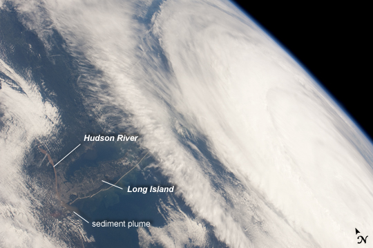 |
| Hurricane Katia off the Northeastern USA Coastline Hurricane Katia had diminished to Category 1 strength on the Saffir-Simpson scale at the time this astronaut photograph was taken, but it still presented an impressive cloud circulation as its center passed by the northeastern USA coastline on September 9, 2011. The storm had reached Category 4 strength earlier on September 5, making it the second major hurricane of the 2011 Atlantic hurricane season. Katia remained over open waters of the Atlantic Ocean during its lifetime, unlike two preceding storms of the season - Hurricane Irene and Tropical Storm Lee - that both made landfall on the continental USA. The approximate center of Hurricane Katia is visible at image lower right, with its outer cloud bands extending across the center of the view. A small part of the State of New York - including Long Island and the Hudson River - is visible through a gap in the cloud cover at image lower left. The Hudson River has a chocolate brown coloration due to heavy loading with sediment, a consequence of flooding and erosion of the upstream watershed from the heavy precipitation of Hurricane Irene and Tropical Storm Lee. A plume of sediment is just visible entering the Atlantic Ocean on the southern coastline of Long Island, directly to the south of the New York City metropolitan area (partially obscured by clouds). Crew members on the International Space Station have the opportunity to take images like this one by looking outwards at an angle through Station windows, much like taking photographs of the ground from a commercial airliner window - albeit from an average altitude of ~ 400 km. |
| Images: | All Available Images Low-Resolution 158k |
|
| Mission: | ISS028 |
|
| Roll - Frame: | E - 45516 |
|
| Geographical Name: | USA-MASSACHUSETTS |
|
| Features: | HURRICANE KATIA,LONG ISLAND,HUDSON RIVER,SEDIMENT,ATLANTIC OCEAN,PAN |
|
| Center Lat x Lon: | 41.0N x 70.5W |
|
| Film Exposure: | N=Normal exposure, U=Under exposed, O=Over exposed, F=out of Focus |
|
| Percentage of Cloud Cover-CLDP: | 75 |
|
| Camera:: | N2 |
|
| Camera Tilt: | HO | LO=Low Oblique, HO=High Oblique, NV=Near Vertical |
| Camera Focal Length: | 28 |
|
| Nadir to Photo Center Direction: | E | The direction from the nadir to the center point, N=North, S=South, E=East, W=West |
| Stereo?: | Y=Yes there is an adjacent picture of the same area, N=No there isn't |
|
| Orbit Number: | 1409 |
|
| Date: | 20110909 | YYYYMMDD |
| Time: | 145641 | GMT HHMMSS |
| Nadir Lat: | 38.8N |
Latitude of suborbital point of spacecraft |
| Nadir Lon: | 77.4W |
Longitude of suborbital point of spacecraft |
| Sun Azimuth: | 130 | Clockwise angle in degrees from north to the sun measured at the nadir point |
| Space Craft Altitude: | 207 | nautical miles |
| Sun Elevation: | 45 | Angle in degrees between the horizon and the sun, measured at the nadir point |
| Land Views: | EROSION, ISLAND |
|
| Water Views: | FLOODING, OCEAN, RIVER, SEDIMENT |
|
| Atmosphere Views: | HURRICANE, PLUME |
|
| Man Made Views: | |
|
| City Views: | NEW YORK CITY |
|
Photo is not associated with any sequences | ||
| NASA Home Page |
JSC Home Page |
JSC Digital Image Collection |
Earth Science & Remote Sensing |
|
This service is provided by the International Space Station program and the JSC Earth Science & Remote Sensing Unit, ARES Division, Exploration Integration Science Directorate.

|