Geographic Region: CHINA
Feature: JUNGGAR BASIN,SAND DUNES,IRTYSH RIVER,WETLANDS
|
Geographic Region: CHINA Feature: JUNGGAR BASIN,SAND DUNES,IRTYSH RIVER,WETLANDS |
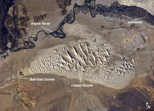 |
| Sand Dunes, Junggar Basin, Northwestern China This striking astronaut photograph taken from the International Space Station highlights a sand dune field within the Burqin-Haba River-Jimunai Desert near the borders of China, Mongolia, Russia, and Kazakhstan. The dune field (approximately 32 km long) is located immediately to the west-northwest of the city of Burqin (not shown), and is part of the Junggar Basin, a region of active petroleum production in northwestern China. The Irtysh River, with associated wetlands and riparian vegetation (appearing grey-green in the image) flows from its headwaters in the Altay Mountains to the east towards Siberia to the west (right to left across the image). Tan sandy linear dunes at image center on the south side of the Irtysh River dominate the view. The linear dunes are formed from mobile barchan (crescent-shaped) dunes moving from left to right in this view; the barchans eventually merge to form the large linear dunes which can reach 50 -100 meters in height. Sand moving along the southern edge of the dune field appears to be feeding a southeastern lobe with a separate population of linear dunes (image lower right). The Burqin-Haba River-Jimunai Desert area also includes darker gravel covered surfaces that form pavements known locally as gobi. These are somewhat indistinguishable from vegetated areas arresting some of the dunes at the resolution of the astronaut photograph, but tend to be located on the flat regions between the dunes. |
| Images: | All Available Images Low-Resolution 312k |
|
| Mission: | ISS028 |
|
| Roll - Frame: | E - 44444 |
|
| Geographical Name: | CHINA |
|
| Features: | JUNGGAR BASIN,SAND DUNES,IRTYSH RIVER,WETLANDS |
|
| Center Lat x Lon: | 47.7N x 86.4E |
|
| Film Exposure: | N=Normal exposure, U=Under exposed, O=Over exposed, F=out of Focus |
|
| Percentage of Cloud Cover-CLDP: | 10 |
|
| Camera:: | N2 |
|
| Camera Tilt: | 08 | LO=Low Oblique, HO=High Oblique, NV=Near Vertical |
| Camera Focal Length: | 180 |
|
| Nadir to Photo Center Direction: | N | The direction from the nadir to the center point, N=North, S=South, E=East, W=West |
| Stereo?: | Y=Yes there is an adjacent picture of the same area, N=No there isn't |
|
| Orbit Number: | 1390 |
|
| Date: | 20110908 | YYYYMMDD |
| Time: | 095951 | GMT HHMMSS |
| Nadir Lat: | 47.2N |
Latitude of suborbital point of spacecraft |
| Nadir Lon: | 86.4E |
Longitude of suborbital point of spacecraft |
| Sun Azimuth: | 248 | Clockwise angle in degrees from north to the sun measured at the nadir point |
| Space Craft Altitude: | 202 | nautical miles |
| Sun Elevation: | 26 | Angle in degrees between the horizon and the sun, measured at the nadir point |
| Land Views: | BASIN, DESERT, DUNE |
|
| Water Views: | RIVER |
|
| Atmosphere Views: | |
|
| Man Made Views: | |
|
| City Views: | MOBILE |
|
Photo is not associated with any sequences | ||
| NASA Home Page |
JSC Home Page |
JSC Digital Image Collection |
Earth Science & Remote Sensing |
|
This service is provided by the International Space Station program and the JSC Earth Science & Remote Sensing Unit, ARES Division, Exploration Integration Science Directorate.

|