
Geographic Region: FRANCE
Feature: PARIS AT NIGHT, ENGLISH CHANNEL,LONDON AT NIGHT,BRUSSELS AT NIGHT
|
Geographic Region: FRANCE Feature: PARIS AT NIGHT, ENGLISH CHANNEL,LONDON AT NIGHT,BRUSSELS AT NIGHT |
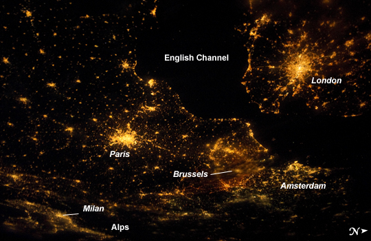 |
| Northwestern Europe at Night Several of the oldest cities of northwestern Europe are highlighted in this astronaut photograph taken from the International Space Station (ISS) at 00:25:26 Greenwich Mean Time (GMT). While the landscape is dotted with numerous clusters of lights from individual urban areas, the metropolitan areas of London (United Kingdom), Paris (France), Brussels (Belgium) and Amsterdam (Netherlands) stand out due to their large light "footprints". The metropolitan area of Milan, Italy is also visible at image lower left. While each of these cities is, or has been, the capital of a kingdom, republic, or empire--Paris and London have been all three--Brussels is also the capital city of the European Union. This astronaut photograph was taken with a short camera lens, providing the large field of view recorded in the image. To give a sense of scale, the centers of the London and Paris metropolitan areas are approximately 340 kilometers distant from each other. The image is also oblique, or taken looking outwards at an angle from the ISS; this tends to foreshorten the image, making the distance between Paris and Milan (~640 kilometers) appear less than that of Paris to London. In contrast to the land surface defined by the city lights, the English Channel at image right presents a uniform dark appearance. Similarly, the Alps (image bottom center) to the north of Milan are also largely devoid of lights. While much of the atmosphere was clear at the time the image was taken, the lights of the Brussels metropolitan area are dimmed by thin cloud cover. |
| Images: | All Available Images Low-Resolution 234k |
|
| Mission: | ISS028 |
|
| Roll - Frame: | E - 24360 |
|
| Geographical Name: | FRANCE |
|
| Features: | PARIS AT NIGHT, ENGLISH CHANNEL,LONDON AT NIGHT,BRUSSELS AT NIGHT |
|
| Center Lat x Lon: | 49.0N x 1.5E |
|
| Film Exposure: | N=Normal exposure, U=Under exposed, O=Over exposed, F=out of Focus |
|
| Percentage of Cloud Cover-CLDP: | 0 |
|
| Camera:: | N5 |
|
| Camera Tilt: | 55 | LO=Low Oblique, HO=High Oblique, NV=Near Vertical |
| Camera Focal Length: | 28 |
|
| Nadir to Photo Center Direction: | E | The direction from the nadir to the center point, N=North, S=South, E=East, W=West |
| Stereo?: | Y=Yes there is an adjacent picture of the same area, N=No there isn't |
|
| Orbit Number: | 931 |
|
| Date: | 20110810 | YYYYMMDD |
| Time: | 002526 | GMT HHMMSS |
| Nadir Lat: | 50.3N |
Latitude of suborbital point of spacecraft |
| Nadir Lon: | 3W |
Longitude of suborbital point of spacecraft |
| Sun Azimuth: | 2 | Clockwise angle in degrees from north to the sun measured at the nadir point |
| Space Craft Altitude: | 201 | nautical miles |
| Sun Elevation: | -24 | Angle in degrees between the horizon and the sun, measured at the nadir point |
| Land Views: | |
|
| Water Views: | CHANNEL |
|
| Atmosphere Views: | |
|
| Man Made Views: | |
|
| City Views: | AMSTERDAM, LONDON, MILAN, PARIS |
|
Photo is not associated with any sequences | ||
| NASA Home Page |
JSC Home Page |
JSC Digital Image Collection |
Earth Science & Remote Sensing |
|
This service is provided by the International Space Station program and the JSC Earth Science & Remote Sensing Unit, ARES Division, Exploration Integration Science Directorate.

|