
Geographic Region: TURKEY
Feature: MT. ARARAT, L. BALIK, ARAS R. V., AGR., YEREVAN, MTS., FOR.
|
Geographic Region: TURKEY Feature: MT. ARARAT, L. BALIK, ARAS R. V., AGR., YEREVAN, MTS., FOR. |
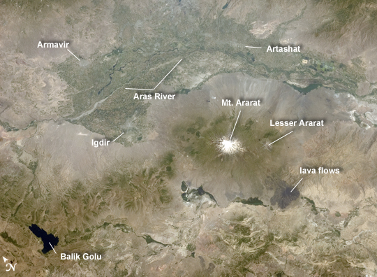 |
| Aras River, Turkey-Armenia -Iran Border Region This astronaut photograph, taken from the International Space Station, highlights a segment of the international border between Turkey to the south-southwest and Armenia to the north-northeast. The Aras River is the physical expression of the closed border between the two countries. Extensive green agricultural fields are common on both sides of the river (image top), as well as a number of gray to tan urban areas including Artashat and Armavir in Armenia and Igdir in Turkey. While there have been efforts to normalize diplomatic relations between the two countries in recent years, the Armenia-Turkey border remains officially closed. The dominant geographic feature in the region is Mt. Ararat, also known as Agri Dagi. The peak of Ararat, a large stratovolcano that last erupted in 1840 according to historical records, is located approximately 40 kilometers to the south of the Armenia-Turkey border. A lower peak to the east, known as Lesser or Little Ararat, is also volcanic in origin. Dark gray lava flows to the south of Mt. Ararat are located near the Turkish border with Iran. While this border is also closed along much of its length, official crossing points allow relatively easy travel between the two countries. The white, glacier-clad peak of Mt. Ararat is evident at image center; dark green areas on the lower slopes indicate where vegetation cover is abundant. A large lake, Balik Golu or Fish Lake, is visible to the west (image lower left). |
| Images: | All Available Images Low-Resolution 245k |
|
| Mission: | ISS028 |
|
| Roll - Frame: | E - 15023 |
|
| Geographical Name: | TURKEY |
|
| Features: | MT. ARARAT, L. BALIK, ARAS R. V., AGR., YEREVAN, MTS., FOR. |
|
| Center Lat x Lon: | 40.0N x 44.5E |
|
| Film Exposure: | N=Normal exposure, U=Under exposed, O=Over exposed, F=out of Focus |
|
| Percentage of Cloud Cover-CLDP: | 10 |
|
| Camera:: | N2 |
|
| Camera Tilt: | 30 | LO=Low Oblique, HO=High Oblique, NV=Near Vertical |
| Camera Focal Length: | 65 |
|
| Nadir to Photo Center Direction: | NE | The direction from the nadir to the center point, N=North, S=South, E=East, W=West |
| Stereo?: | Y=Yes there is an adjacent picture of the same area, N=No there isn't |
|
| Orbit Number: | 421 |
|
| Date: | 20110708 | YYYYMMDD |
| Time: | 081611 | GMT HHMMSS |
| Nadir Lat: | 38.6N |
Latitude of suborbital point of spacecraft |
| Nadir Lon: | 43.1E |
Longitude of suborbital point of spacecraft |
| Sun Azimuth: | 139 | Clockwise angle in degrees from north to the sun measured at the nadir point |
| Space Craft Altitude: | 208 | nautical miles |
| Sun Elevation: | 70 | Angle in degrees between the horizon and the sun, measured at the nadir point |
| Land Views: | GLACIER |
|
| Water Views: | LAKE, RIVER |
|
| Atmosphere Views: | |
|
| Man Made Views: | |
|
| City Views: | |
|
Photo is not associated with any sequences | ||
| NASA Home Page |
JSC Home Page |
JSC Digital Image Collection |
Earth Science & Remote Sensing |
|
This service is provided by the International Space Station program and the JSC Earth Science & Remote Sensing Unit, ARES Division, Exploration Integration Science Directorate.

|