Geographic Region: ETHIOPIA
Feature: AGRICULTURAL FIELDS, CANALS, SUNGLINT, SHABEELLE RIVER
|
Geographic Region: ETHIOPIA Feature: AGRICULTURAL FIELDS, CANALS, SUNGLINT, SHABEELLE RIVER |
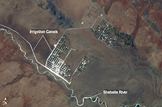 |
| Agricultural Fields along the Shebelle River, Ethiopia Note: This caption refers to the image versions labeled "NASA's Earth Observatory web site". The Shebelle River supports limited agricultural development within the arid to semi-arid Ogaden Plateau region of southeastern Ethiopia. This detailed astronaut photograph illustrates a network of irrigation canals and fields located approximately 42 kilometers to the west-northwest of the city of Gode, Ethiopia. Floodplain sediments and soils are dark brown to gray (image center), and contrast with reddish rocks and soils of the adjacent plateau. Water in the Shebelle River, and the irrigation canals, has a bright, mirror-like appearance due to sunglint, or light reflecting off the water surface back towards the astronaut observer on the International Space Station. Vegetation in the floodplain (image top center) and agricultural fields is dark green. The river water supports a variety of crops--the most common being sorghum and maize --as well as grazing for livestock (cattle, sheep, goats, and camels). The Shebelle River has its headwaters in the Ethiopian Highlands, and transports water and sediment 1000 kilometers to the southeast across Ethiopia, continuing an additional 130 kilometers into neighboring Somalia. The Shebelle River does not reach the Indian Ocean during most years, but disappears into the sands near the coast in Somalia. During periods of heavy rainfall and flooding however, the Shebelle can reach the Indian Ocean. |
| Images: | All Available Images Low-Resolution 188k |
|
| Mission: | ISS027 |
|
| Roll - Frame: | E - 9564 |
|
| Geographical Name: | ETHIOPIA |
|
| Features: | AGRICULTURAL FIELDS, CANALS, SUNGLINT, SHABEELLE RIVER |
|
| Center Lat x Lon: | 6.0N x 43.2E |
|
| Film Exposure: | N=Normal exposure, U=Under exposed, O=Over exposed, F=out of Focus |
|
| Percentage of Cloud Cover-CLDP: | 10 |
|
| Camera:: | N2 |
|
| Camera Tilt: | 10 | LO=Low Oblique, HO=High Oblique, NV=Near Vertical |
| Camera Focal Length: | 400 |
|
| Nadir to Photo Center Direction: | NW | The direction from the nadir to the center point, N=North, S=South, E=East, W=West |
| Stereo?: | Y=Yes there is an adjacent picture of the same area, N=No there isn't |
|
| Orbit Number: | 2865 |
|
| Date: | 20110331 | YYYYMMDD |
| Time: | 093337 | GMT HHMMSS |
| Nadir Lat: | 5.7N |
Latitude of suborbital point of spacecraft |
| Nadir Lon: | 43.7E |
Longitude of suborbital point of spacecraft |
| Sun Azimuth: | 256 | Clockwise angle in degrees from north to the sun measured at the nadir point |
| Space Craft Altitude: | 190 | nautical miles |
| Sun Elevation: | 84 | Angle in degrees between the horizon and the sun, measured at the nadir point |
| Land Views: | PLATEAU |
|
| Water Views: | RIVER, SEDIMENT, SUNGLINT |
|
| Atmosphere Views: | |
|
| Man Made Views: | |
|
| City Views: | |
|
Photo is not associated with any sequences | ||
| NASA Home Page |
JSC Home Page |
JSC Digital Image Collection |
Earth Science & Remote Sensing |
|
This service is provided by the International Space Station program and the JSC Earth Science & Remote Sensing Unit, ARES Division, Exploration Integration Science Directorate.

|