
Geographic Region: PACIFIC OCEAN
Feature: WEAKENING SURFACE LOW PRESSURE SYSTEM, CENTER OF ANOTHER LOW SOUTHWARD
|
Geographic Region: PACIFIC OCEAN Feature: WEAKENING SURFACE LOW PRESSURE SYSTEM, CENTER OF ANOTHER LOW SOUTHWARD |
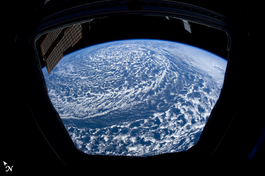 |
| Low Pressure System in View, Eastern North Pacific From one of the six trapezoidal windows in the International Space Station (ISS) cupola, the astronauts have a field of view covering an area equal to the length of California, and as wide as from the California coast to central Colorado. The cyclonic vortex visible in this image from the cupola occurred within a large area of low pressure over the eastern north Pacific extending along the entire coast of California to Vancouver Island, Canada. A more vigorous low pressure system (see image ISS027-E-6501) was located to the south of this weaker system. This image shows a weak low pressure area which still has the appropriate conditions to maintain cloud development accompanying the counter-clockwise winds. The cupola is a panoramic control center for the ISS; it is a dome-shaped module with windows designed for observing and guiding robotic operations outside of the Station. Part of one of the ISS solar panel arrays is visible outside the cupola at image upper left. The 360 degree view not only provides viewing for operating the robotic workstation but also for observing the Earth and celestial bodies. |
| Images: | All Available Images Low-Resolution 169k |
|
| Mission: | ISS027 |
|
| Roll - Frame: | E - 6500 |
|
| Geographical Name: | PACIFIC OCEAN |
|
| Features: | WEAKENING SURFACE LOW PRESSURE SYSTEM, CENTER OF ANOTHER LOW SOUTHWARD |
|
| Center Lat x Lon: | 40.5N x 134W |
|
| Film Exposure: | N=Normal exposure, U=Under exposed, O=Over exposed, F=out of Focus |
|
| Percentage of Cloud Cover-CLDP: | 100 |
|
| Camera:: | N5 |
|
| Camera Tilt: | HO | LO=Low Oblique, HO=High Oblique, NV=Near Vertical |
| Camera Focal Length: | 16 |
|
| Nadir to Photo Center Direction: | N | The direction from the nadir to the center point, N=North, S=South, E=East, W=West |
| Stereo?: | Y=Yes there is an adjacent picture of the same area, N=No there isn't |
|
| Orbit Number: | 2686 |
|
| Date: | 20110320 | YYYYMMDD |
| Time: | 001836 | GMT HHMMSS |
| Nadir Lat: | 33.0N |
Latitude of suborbital point of spacecraft |
| Nadir Lon: | 134.2W |
Longitude of suborbital point of spacecraft |
| Sun Azimuth: | 244 | Clockwise angle in degrees from north to the sun measured at the nadir point |
| Space Craft Altitude: | 188 | nautical miles |
| Sun Elevation: | 34 | Angle in degrees between the horizon and the sun, measured at the nadir point |
| Land Views: | COAST, ISLAND |
|
| Water Views: | |
|
| Atmosphere Views: | |
|
| Man Made Views: | |
|
| City Views: | |
|
Photo is not associated with any sequences | ||
| NASA Home Page |
JSC Home Page |
JSC Digital Image Collection |
Earth Science & Remote Sensing |
|
This service is provided by the International Space Station program and the JSC Earth Science & Remote Sensing Unit, ARES Division, Exploration Integration Science Directorate.

|