
Geographic Region: TURKEY
Feature: IZMIR METROPOLITAN AREA,GULF OF IZMIR,URBAN LAND COVER
|
Geographic Region: TURKEY Feature: IZMIR METROPOLITAN AREA,GULF OF IZMIR,URBAN LAND COVER |
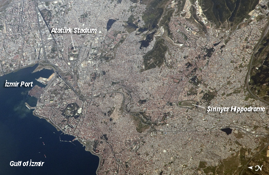 |
| İzmir Metropolitan Area, İzmir Province, Turkey The metropolis of İzmir is located in the western Anatolia region of Turkey. It is the country's third largest city in terms of population and the second largest port city (after Istanbul). The İzmir region has included urban areas for almost 3500 years, and the ancient core of the metropolitan area was originally known as Smyrna. Due to its location on the Gulf of İzmir (image lower left) with access to the Aegean Sea, İzmir (or Smyrna) has been an important Mediterranean Sea port for most of its history. This detailed astronaut photograph highlights the modern urban landscape of the İzmir metropolitan area. Today, the metropolitan area includes eleven districts, many of which were independent neighborhoods prior to agglomeration into "greater İzmir". Densely built-up residential and commercial districts, characterized by gray to reddish gray rooftops occupy much of the central part of the image. Larger structures with bright white rooftops are indicative of commercial/industrial areas near the İzmir Port at image left. Two large sport complexes, the Ataturk Stadium and Şirinyer Hippodrome (horse racing track) are clearly visible at image upper left and image right respectively. Numerous vegetated parks (green) are located throughout the area. In addition to being a major trade center, greater İzmir is a hub for regional tourism. |
| Images: | All Available Images Low-Resolution 264k |
|
| Mission: | ISS027 |
|
| Roll - Frame: | E - 33889 |
|
| Geographical Name: | TURKEY |
|
| Features: | IZMIR METROPOLITAN AREA,GULF OF IZMIR,URBAN LAND COVER |
|
| Center Lat x Lon: | 38.4N x 27.2E |
|
| Film Exposure: | N=Normal exposure, U=Under exposed, O=Over exposed, F=out of Focus |
|
| Percentage of Cloud Cover-CLDP: | 10 |
|
| Camera:: | N2 |
|
| Camera Tilt: | 55 | LO=Low Oblique, HO=High Oblique, NV=Near Vertical |
| Camera Focal Length: | 800 |
|
| Nadir to Photo Center Direction: | SW | The direction from the nadir to the center point, N=North, S=South, E=East, W=West |
| Stereo?: | Y=Yes there is an adjacent picture of the same area, N=No there isn't |
|
| Orbit Number: | 3588 |
|
| Date: | 20110516 | YYYYMMDD |
| Time: | 065031 | GMT HHMMSS |
| Nadir Lat: | 40.7N |
Latitude of suborbital point of spacecraft |
| Nadir Lon: | 30.9E |
Longitude of suborbital point of spacecraft |
| Sun Azimuth: | 105 | Clockwise angle in degrees from north to the sun measured at the nadir point |
| Space Craft Altitude: | 184 | nautical miles |
| Sun Elevation: | 46 | Angle in degrees between the horizon and the sun, measured at the nadir point |
| Land Views: | |
|
| Water Views: | GULF |
|
| Atmosphere Views: | |
|
| Man Made Views: | PORT |
|
| City Views: | IZMIR |
|
Photo is not associated with any sequences | ||
| NASA Home Page |
JSC Home Page |
JSC Digital Image Collection |
Earth Science & Remote Sensing |
|
This service is provided by the International Space Station program and the JSC Earth Science & Remote Sensing Unit, ARES Division, Exploration Integration Science Directorate.

|