
Geographic Region: USA-ARIZONA
Feature: CHIRICAHUA MOUNTAINS, HORSESHOE 2 FIRE PLUME,WILLCOX PLAYA
|
Geographic Region: USA-ARIZONA Feature: CHIRICAHUA MOUNTAINS, HORSESHOE 2 FIRE PLUME,WILLCOX PLAYA |
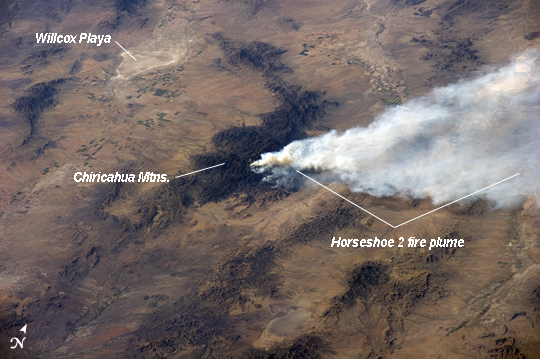 |
| Horseshoe 2 Fire, southeastern Arizona The Horseshoe 2 fire, located along the southeastern flank of the Chiricahua Mountains in southeastern Arizona, began on May 8, 2011 at approximately 11:00am. The fire is thought to have been started by human activities. This astronaut photograph illustrates the area (approximately 8900 hectares, or 22110 acres) and position of the fire within the mountains on May 15, 2011, as well as an extensive smoke plume extending to the east-northeast over a distance of at least 60 kilometers (approximately 40 miles). As of May 19 2011, the fire had burned an area of nearly 14000 hectares (approximately 34400 acres) of grasses, shrubs, and trees along the mountain slopes. The Chiricahua Mountains are included within the Chiricahua National Monument located near the borders of Arizona, USA; New Mexico, USA; and Chihuahua, United Mexican States. Elevations in the mountains range from approximately 914 - 3267 meters (300 - 10720 feet) above sea level. The higher elevations--known regionally as "sky islands"--allow for biologically diverse plant and animal communities, adapted to cooler and wetter conditions, to survive while surrounded by semi-arid to arid desert conditions at lower elevations. The image highlights this contrast in environments; pine and oak forest contributes to the dark coloration of the upper slopes and peaks of the Chiricahuas at image center, while the flat, gray to tan surface of Willcox Playa to the northwest is indicative of the adjacent desert environment. |
| Images: | All Available Images Low-Resolution 207k |
|
| Mission: | ISS027 |
|
| Roll - Frame: | E - 31908 |
|
| Geographical Name: | USA-ARIZONA |
|
| Features: | CHIRICAHUA MOUNTAINS, HORSESHOE 2 FIRE PLUME,WILLCOX PLAYA |
|
| Center Lat x Lon: | 31.8N x 109.2W |
|
| Film Exposure: | N=Normal exposure, U=Under exposed, O=Over exposed, F=out of Focus |
|
| Percentage of Cloud Cover-CLDP: | 10 |
|
| Camera:: | N5 |
|
| Camera Tilt: | HO | LO=Low Oblique, HO=High Oblique, NV=Near Vertical |
| Camera Focal Length: | 200 |
|
| Nadir to Photo Center Direction: | NW | The direction from the nadir to the center point, N=North, S=South, E=East, W=West |
| Stereo?: | Y=Yes there is an adjacent picture of the same area, N=No there isn't |
|
| Orbit Number: | 3583 |
|
| Date: | 20110515 | YYYYMMDD |
| Time: | 233610 | GMT HHMMSS |
| Nadir Lat: | 27.1N |
Latitude of suborbital point of spacecraft |
| Nadir Lon: | 105.1W |
Longitude of suborbital point of spacecraft |
| Sun Azimuth: | 279 | Clockwise angle in degrees from north to the sun measured at the nadir point |
| Space Craft Altitude: | 185 | nautical miles |
| Sun Elevation: | 26 | Angle in degrees between the horizon and the sun, measured at the nadir point |
| Land Views: | DESERT, FOREST, MOUNTAIN, RANGE |
|
| Water Views: | PLAYA |
|
| Atmosphere Views: | PLUME, SMOKE |
|
| Man Made Views: | |
|
| City Views: | |
|
Photo is not associated with any sequences | ||
| NASA Home Page |
JSC Home Page |
JSC Digital Image Collection |
Earth Science & Remote Sensing |
|
This service is provided by the International Space Station program and the JSC Earth Science & Remote Sensing Unit, ARES Division, Exploration Integration Science Directorate.

|